| CPC G01S 13/878 (2013.01) [G01S 13/765 (2013.01); G01S 13/86 (2013.01); G01S 13/933 (2020.01)] | 27 Claims |
|
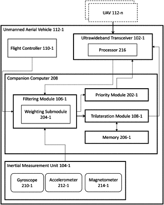
1. A method for determining a position of a first unmanned aerial vehicle with respect to a first set of unmanned aerial vehicles including at least a second unmanned aerial vehicle, a third unmanned aerial vehicle, and a fourth unmanned aerial vehicle comprising:
a) obtaining, at the first unmanned aerial vehicle, a first set of estimated position information associated with the first unmanned aerial vehicle, wherein the first set of estimated position information comprises a respective three-dimensional distance information associated with each unmanned aerial vehicle of the first set of unmanned aerial vehicles relative to the first unmanned aerial vehicle;
b) generating, by a processor associated with a first ultra-wideband transceiver mounted on the first unmanned aerial vehicle, a first set of estimated range determinations with respect to each respective unmanned aerial vehicle in the first set of unmanned aerial vehicles, wherein each respective estimated range determination is associated with a respective range timestamp;
c) obtaining, by a filtering module of the first unmanned aerial vehicle:
1. the first set of estimated range determinations along with the first set of estimated position information associated with the first unmanned aerial vehicle from the processor of the first ultra-wideband transceiver;
2. first location information from a first navigation system of the first unmanned aerial vehicle, wherein the first location information is associated with a first respective sensor timestamp;
3. first acceleration information from a first inertial measurement unit of the first unmanned aerial vehicle, wherein the first acceleration information is associated with a second respective sensor timestamp;
4. first angular rate information from the first inertial measurement unit of the first unmanned aerial vehicle, wherein the first angular rate information is associated with a third respective sensor timestamp; and
5. first magnetic field information from a first magnetometer of the first unmanned aerial vehicle, wherein the first magnetic field information is associated with a fourth respective sensor timestamp;
d) determining, using a weighting submodule of the filtering module, a respective weight for each of the first set of estimated range determinations, the first location information, the first acceleration information, the first angular rate information, and the first magnetic field information based on:
i. one or more predetermined weighting factors;
ii. the respective range timestamp associated with each estimated range determination;
iii. the first respective sensor timestamp;
iv. the second respective sensor timestamp;
v. the third respective sensor timestamp; and
vi. the fourth respective sensor timestamp;
e) generating, by the filtering module, a first set of filtered estimated ranges associated with each respective unmanned aerial vehicle in the first set of unmanned aerial vehicles based on the first set of estimated position information, the first set of estimated range determinations, the first location information, the first acceleration information, the first angular rate information, and the first magnetic field information, and the respective weight determined for each of the first set of estimated range determinations, the first location information, the first acceleration information, the first angular rate information, and the first magnetic field information;
f) processing, by a trilateration module of the first unmanned aerial vehicle, the first set of filtered estimated ranges associated with each unmanned aerial vehicle of the first set of unmanned aerial vehicles to generate a second set of estimated position information associated with the first unmanned aerial vehicle, by the steps of:
1. obtaining, by the trilateration module, the first set of filtered estimated ranges associated with each respective unmanned aerial vehicle in the first set of unmanned aerial vehicles;
2. determining, by the trilateration module, a first set of magnitude error estimates based on the first set of filtered estimated ranges and the first set of estimated position information, wherein each magnitude error estimate comprises an error between a position of the first unmanned aerial vehicle and the position of each unmanned aerial vehicle in the first set of unmanned aerial vehicles;
3. determining, by the trilateration module, a first three-dimensional direction which minimizes the error between the position of the first unmanned aerial vehicle and the position of each unmanned aerial vehicle in the first set of unmanned aerial vehicles based on the first set of magnitude error estimates; and
4. generating, by the trilateration module, a second set of estimated position information associated with the first unmanned aerial vehicle as a first output based on the first three-dimensional direction and the first set of estimated position information; and
g) transmitting, by the processor of the first ultra-wideband transceiver, the second set of estimated position information to the first navigation system of the first unmanned aerial vehicle.
|