| US 11,733,340 B1 | ||
| Short baseline interferometer (sbi) geolocation using nelder-mead | ||
| Richard Schiffmiller, Teaneck, NJ (US) | ||
| Assigned to BAE Systems Information and Electronic Systems Integration Inc., Nashua, NH (US) | ||
| Filed by BAE Systems Information and Electronic Systems Integration Inc., Nashua, NH (US) | ||
| Filed on Feb. 18, 2020, as Appl. No. 16/793,395. | ||
| Claims priority of provisional application 62/810,154, filed on Feb. 25, 2019. | ||
| Int. Cl. G01S 5/02 (2010.01); G01S 3/50 (2006.01); G01S 5/06 (2006.01); G01S 3/48 (2006.01); G01S 3/56 (2006.01); G01S 5/04 (2006.01) | ||
| CPC G01S 5/0221 (2013.01) [G01S 3/50 (2013.01); G01S 5/06 (2013.01); G01S 3/48 (2013.01); G01S 3/56 (2013.01); G01S 5/04 (2013.01); G01S 5/0278 (2013.01)] | 20 Claims |
|
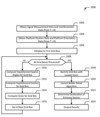
1. A computer program product including one or more non-transitory machine-readable mediums encoding instructions that when executed by one or more processors cause a process to be carried out for determining a true bearing angle from a spatial angle, the process comprising:
receiving a plurality of pulses of an electromagnetic signal emitted by an emission source, the plurality of pulses comprising a first pulse and a second pulse; computing a first measured spatial angle computed for the first pulse; computing a second measured spatial angle computed for the second pulse; computing an angle-of-arrival of the electromagnetic signal and a range to the electromagnetic signal; generating a grid based on the angle-of-arrival of, and the range to, the electromagnetic signal, the grid comprising a plurality of grid boxes; computing first and second hypothesized spatial angles for each of first and second grid boxes; computing a score for each of the first and second grid boxes, wherein the score for the first grid box is based on the first and second hypothesized spatial angles computed for the first grid box and the first and second measured spatial angles, and wherein the score for the second grid box is based on the first and second hypothesized spatial angles computed for the second grid box and the first and second measured spatial angles; identifying a grid box of the plurality of grid boxes as a seed location; launching a Nelder-Mead algorithm using the seed location; and determining a geographic location of the emission source based on results from the Nelder-Mead algorithm, wherein determining the geographic location comprises computing a true bearing angle to the emission source. |