| CPC G01C 21/367 (2013.01) [G09B 29/106 (2013.01)] | 20 Claims |
|
1. A method for providing a map scale comprising:
providing, by one or more processors, a geographic area for display on a display of a device;
receiving, by the one or more processors, first information corresponding to a first input associated with a first view of the geographic area;
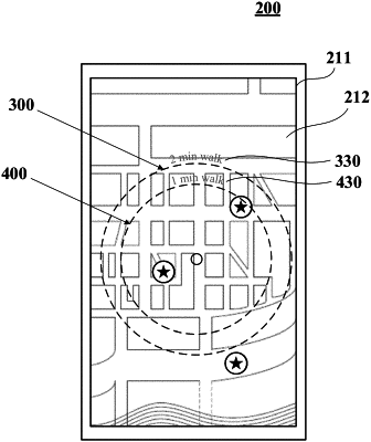
providing, in response to the first information and for display on the display, by the one or more processors, a first scale including a first graphic and a second graphic surrounding the first graphic within the geographic area;
calculating, by the one or more processors, a first distance between the first graphic and the second graphic;
providing, by the one or more processors, a first reference value for display on the display, the first reference value including at least one of a time or distance to travel between the first and second graphics of the first scale, the time or distance to travel being based on the calculated first distance;
receiving, by the one or more processors, update information corresponding to a second input associated with an updated view of the geographic area, the updated view corresponding to a zoom or pan of the geographic area or a centering of a selected point within the geographic area;
providing, in response to the update information and for display on the display, by the one or more processors, an updated scale including a third graphic and a fourth graphic surrounding the third graphic within the updated view of the geographic area, the updated scale recentering the first scale within the updated view of the geographic area;
calculating, by the one or more processors, an updated distance between the third graphic and the fourth graphic of the updated scale; and
providing, by the one or more processors, an updated reference value for display on the display, the updated reference value including at least one of a time or distance to travel between the third and fourth graphics of the updated scale, the time or distance to travel based on the calculated updated distance.
|