| CPC H04W 16/18 (2013.01) [H04W 24/02 (2013.01); H04W 64/003 (2013.01); H04W 84/045 (2013.01); G07F 17/0078 (2013.01)] | 6 Claims |
|
1. A method for automatic deployment of at least one outdoor small cell in a geographic location, the method configured to minimize interference, the method comprising:
dynamically collecting, by a data collection module, a traffic data corresponding to a geographic location associated with a cellular network comprising of one or more cells;
identifying, by a location identification module, a group of spatial grids from the one or more cells within the geographic location based on the traffic data, comprising:
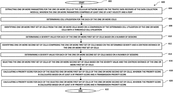
extracting one or more parameters for the one or more cells of the cellular network based on the traffic data received at the data collection module, wherein the one or more parameters comprise at least a Reference Signal Receive Power (RSRP);
determining cell utilization for the each of the one or more cells;
identifying one or more first set of spatial grids from the one or more cells based on a comparison of the determined cell utilization of the one or more cells with a threshold cell utilization;
determining a severity value for each of the one or more first set of spatial grids based on a number of sessions;
identifying one or more second set of spatial grids comprising the one or more first set of spatial grids based on the determined severity and a centroid distance of the one or more first set of spatial grids;
determining a severity value for each of the one or more second set of spatial grids based on a number of sessions;
selecting the one or more first set of spatial grids of the one or more second set of spatial grids based on the severity value and the centroid distance of the one or more first set of spatial grids;
calculating a priority score for each of the selected one or more first set of spatial grids of the one or more second set of spatial grids, wherein the priority score is calculated based on at least a RF priority score and a transmission priority score; and
identifying one or more third set of cells as the group of spatial grids based on the calculated priority score;
determining, by the location identification module, one or more locations within the geographic locations for deploying the at least one outdoor small cell based on the identified group of spatial grids, to minimize interference within the one or more cells;
determining, by a backhaul link clearance module, a backhaul connection between the one or more determined locations with the cellular network;
determining, by an azimuth planning module, an azimuth for the at least one outdoor small cell based on the determined connection; and
deploying, by a deployment unit, the at least one outdoor small cell based on at least one of the determined one or more locations, the determined azimuth and the determined backhaul connection.
|