| CPC H04N 17/002 (2013.01) [B64C 39/024 (2013.01); B64D 47/08 (2013.01); G06T 7/246 (2017.01); G06T 7/73 (2017.01); G06V 20/13 (2022.01); G06V 20/17 (2022.01); G06V 20/52 (2022.01); G06V 40/10 (2022.01); G06V 40/20 (2022.01); H04N 23/90 (2023.01); B64U 10/13 (2023.01); B64U 2101/30 (2023.01); G06T 2207/30232 (2013.01); G06T 2207/30244 (2013.01)] | 20 Claims |

|
1. A computer-implemented method comprising:
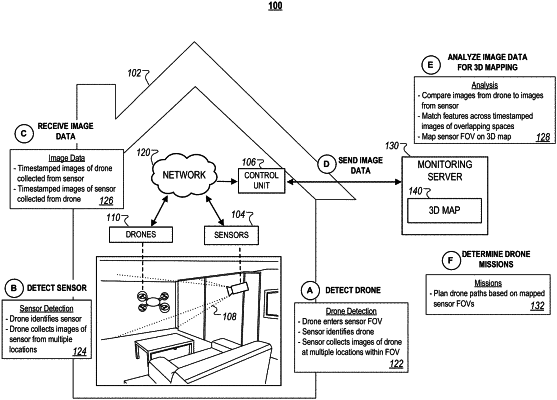
detecting, for deployment of a drone to a blind spot of an installed sensor at a building to increase sensor coverage of the building and using time-varying poses pests of the drone and time-varying locations of the drone to which the time-varying poses are mapped to discover boundaries of a detection area for the installed sensor using the time-varying poses to which none of the time-varying locations were mapped and to determine the blind spot using the boundaries of the detection area, the drone in sensor data captured by the installed sensor at a fixed location of the building,
wherein the drone includes a second sensor that is a different sensor than the installed sensor at the fixed location of the building;
discovering the boundaries of the detection area of the installed sensor relative to the location of the installed sensor using data that indicates movement of the drone after the drone is detected,
the discovering comprising:
receiving, from the drone, first timestamped pose data indicating the time-varying poses of the drone during a time period after the drone is detected by the installed sensor;
receiving, from the installed sensor, second timestamped data indicating the time-varying locations of the drone within the detection area of the installed sensor during the time period after the drone is detected by the installed sensor,
wherein the first timestamped pose data is a different type of data from the second timestamped data;
mapping, using the first timestamped pose data from the drone and the second timestamped data from the installed sensor, a) the time-varying poses of the drone during the time period after the drone is detected by the installed sensor indicated by the first timestamped pose data received from the drone to b) the time-varying locations of the drone within the detection area of the installed sensor during the time period after the drone is detected by the installed sensor indicated by the second timestamped data received from the installed sensor;
detecting, in the time-varying poses of the drone during the time period after the drone is detected by the installed sensor, one or more first time-varying poses of the drone to which none of to the time-varying locations of the drone within the detection area of the installed sensor were mapped in the mapping of a) the time-varying poses of the drone during the time period after the drone is detected by the installed sensor to b) the time-varying locations of the drone within the detection area of the installed sensor during the time period after the drone is detected by the installed sensor; and
discovering the boundaries of the detection area of the installed sensor relative to the location of the installed sensor using the one or more first time-varying poses of the drone to which none of the time-varying locations of the drone within the detection area of the installed sensor were mapped;
determining, using the boundaries of the detection area of the installed sensor discovered using the one or more first time-varying poses of the drone to which none of the time-varying locations of the drone within the detection area of the installed sensor were mapped, the blind spot of the installed sensor; and
determining to increase sensor coverage of the building using the second sensor of the drone by deploying the drone to a destination within the blind spot of the installed sensor.
|