US 11,727,679 B2
Automatic terrain evaluation of landing surfaces, and associated systems and methods
Zhenyu Zhu, Shenzhen (CN); Honghui Zhang, Shenzhen (CN); and You Zhou, Shenzhen (CN)
Assigned to SZ DJI TECHNOLOGY CO., LTD., Shenzhen (CN)
Filed by SZ DJI TECHNOLOGY CO., LTD., Shenzhen (CN)
Filed on May 26, 2021, as Appl. No. 17/330,558.
Application 17/330,558 is a continuation of application No. 16/264,239, granted, now 11,022,984, previously published as PCT/CN2016/093767, filed on Aug. 6, 2016.
Prior Publication US 2021/0286377 A1, Sep. 16, 2021
Int. Cl. G06V 20/13 (2022.01); B64D 47/08 (2006.01); B64C 39/02 (2023.01); B64D 45/08 (2006.01); G06V 20/64 (2022.01); G06V 20/17 (2022.01); G06T 7/593 (2017.01); G05D 1/04 (2006.01); B64U 70/00 (2023.01); B64U 101/30 (2023.01); G05D 1/00 (2006.01)
CPC G06V 20/13 (2022.01) [B64C 39/024 (2013.01); B64D 45/08 (2013.01); B64D 47/08 (2013.01); G05D 1/042 (2013.01); G06T 7/593 (2017.01); G06V 20/17 (2022.01); G06V 20/64 (2022.01); B64U 70/00 (2023.01); B64U 2101/30 (2023.01); G05D 1/0038 (2013.01); G06T 2207/10012 (2013.01); G06T 2207/10028 (2013.01); G06T 2207/10032 (2013.01); G06T 2207/30181 (2013.01)] 20 Claims
OG exemplary drawing
 
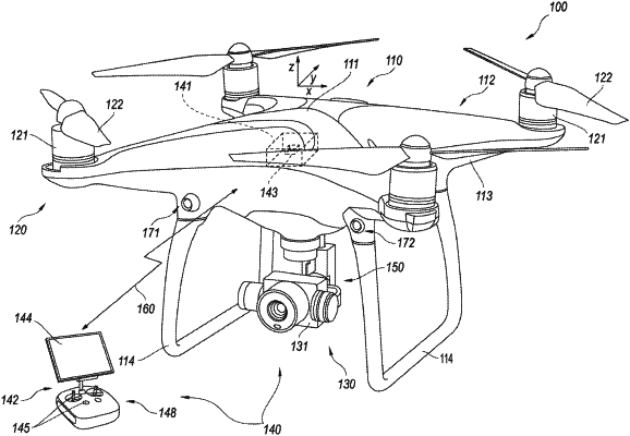
1. A computer-implemented method for controlling landing of a movable object, comprising:
receiving a request to land the movable object on a surface;
in response to the request, obtaining a depth map of the surface, each pixel of the depth map corresponding to a portion of the surface;
controlling the movable object to land based on flatness or tilt of the depth map.