| CPC G06T 7/337 (2017.01) [G01S 7/4817 (2013.01); G01S 17/89 (2013.01); G06F 30/13 (2020.01); G06T 7/001 (2013.01); G06T 7/521 (2017.01); G06T 2207/10024 (2013.01); G06T 2207/10028 (2013.01); G06T 2207/30168 (2013.01); G06T 2207/30252 (2013.01)] | 32 Claims |
|
1. A system for measuring coordinate values of an environment, the system comprising:
a coordinate measurement scanner comprising a light source, an image sensor, and a controller, the light source steering a beam of light to illuminate object points in the environment, the image sensor is arranged to receive light reflected from the object points to determine coordinates of the object points in the environment; and
one or more processors operably coupled to the scanner, the one or more processors being responsive to executable instructions for performing a method comprising:
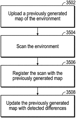
receiving a previously generated map of the environment, the previously generated map comprising a plurality of features;
causing the scanner to measure a plurality of coordinate values as the scanner is moved through the environment, the coordinate values forming a point cloud;
registering the plurality of coordinate values and at least a subset of the features of the previously generated map into a single frame of reference; and
generating a current map of the environment based at least in part on the previously generated map and the point cloud.
|