| CPC G01S 17/42 (2013.01) [G01S 7/4861 (2013.01); G01S 17/931 (2020.01); G01S 19/51 (2013.01); G05D 1/0088 (2013.01); G05D 1/024 (2013.01)] | 20 Claims |
|
1. An autonomous vehicle (AV) system configured to control a vehicle, the system comprising:
one or more processors of a machine; and
a machine-storage medium storing instructions that, when executed by the one or more processors, cause the machine to perform operations comprising:
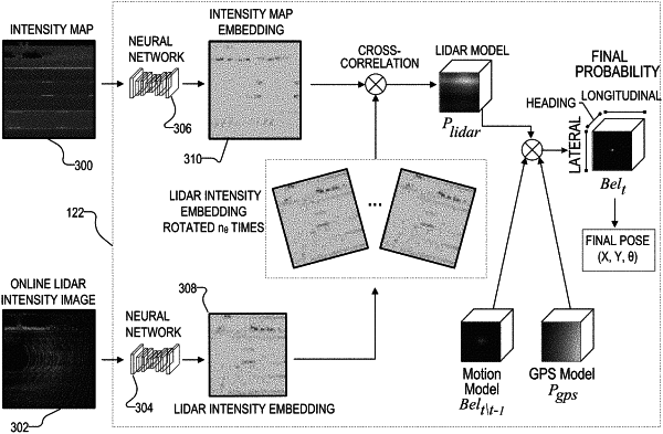
generating, using a first embedding function, an intensity map embedding based on a Lidar intensity map, the Lidar intensity map comprising a map image encoded with Lidar intensity data, the intensity map embedding comprising a representation of the Lidar intensity map computed by the first embedding function, the map image comprising a birds-eye view (BEV) image of an environment;
generating, using a second embedding function, an online Lidar intensity embedding based on an online Lidar intensity image, the online lidar intensity image comprising a BEV rasterized image generated by aggregating point data output by a Lidar system during operation of the vehicle, the aggregating using IMU data and wheel odometer read information, the online Lidar intensity embedding comprising a representation of the online Lidar intensity image computed by the second embedding function, the point data comprising multiple point clouds;
transforming the online Lidar intensity embedding into a coordinate frame of the intensity map embedding;
generating a plurality of pose candidates based on the online Lidar intensity embedding;
computing a three-dimensional (3D) score map based on a comparison of the intensity map embedding with each pose candidate in the plurality of pose candidates, the 3D score map comprising a plurality of match scores, the plurality of match scores comprising a match score for a pose candidate in the plurality of pose candidates, the match score for the pose candidate indicating a similarity between the pose candidate and the map embedding;
determining a pose of the vehicle based on the 3D score map, the pose of the vehicle corresponding to the pose candidate, the pose of the vehicle comprising a longitude, a latitude, and a heading; and
controlling one or more operations of the vehicle based on the pose.
|