| CPC G01C 21/165 (2013.01) [G01C 21/1652 (2020.08); G01C 21/30 (2013.01); G01C 21/3804 (2020.08); G01S 17/06 (2013.01); G01S 17/89 (2013.01)] | 18 Claims |
|
1. A method, comprising:
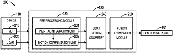
obtaining inertial measurement data of a device at a first time and point cloud data collected by a LiDAR on the device at the first time;
determining, by integrating the inertial measurement data, inertial positioning information of the device in an inertial coordinate system at the first time based on the inertial measurement data; and
determining, based on the inertial positioning information, the point cloud data and at least one local map built in a local coordinate system, a first positioning result of the device in the local coordinate system at the first time,
wherein the at least one local map is built based on a plurality of frames of historical point cloud data collected by the LiDAR on the device, and
wherein the determining the first positioning result comprises:
determining a first posterior probability associated with the first positioning result based on a second positioning result of the device at a second time prior to the first time, the point cloud data, the inertial positioning information, and the at least one local map; and
determining the first positioning result by maximizing the first posterior probability.
|