| CPC G06T 3/4061 (2013.01) [G06F 18/251 (2023.01); G06T 3/4007 (2013.01); G06T 3/4069 (2013.01); G06T 3/4076 (2013.01); G06V 10/803 (2022.01); G06V 10/247 (2022.01)] | 27 Claims |
|
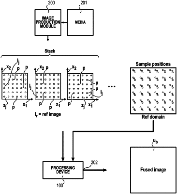
1. A method for processing a sequence of respective top view images of a same terrestrial location, each respective top view image having pixels and pixel values, comprising the following steps:
choosing one image, called reference image, among the respective top view images,
estimating for each respective top view image a respective geometric deformation between the respective top view image and the reference image,
computing by the respective geometric deformations respective subpixel positions of the respective top view images relative to one high-resolution coordinate system,
interpolating at the respective subpixel positions to sample at least part of at least some of the respective top view images on a prescribed grid to obtain a high-resolution image.
|