| CPC G06Q 50/165 (2013.01) [G06Q 10/063 (2013.01); G06Q 50/16 (2013.01); G06Q 90/20 (2013.01)] | 20 Claims |
|
1. A system, comprising:
at least one computer system;
a memory comprising computer readable instructions executable by the at least one computer system, wherein when executed the instructions cause the at least one computer system to at least:
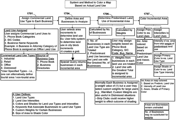
divide, by an application executed in the at least one computer system, a selected map area to define a plurality of incremental areas according to a predetermined grid increment;
query, by the application, a database to retrieve a plurality of businesses within a respective incremental area of the plurality of incremental areas, wherein the query returns each of the plurality of businesses in association with a corresponding land use type of a plurality of land use types;
identify, by the application, a predominant land use type for the respective incremental area based on a total weighted land use value of a plurality of weighted land use values for a plurality of businesses corresponding to the predominant land use type identified to be within the respective incremental area; and
automatically generate, by the application, a land use map that colors the respective incremental area using a predetermined color assigned to the predominant land use type for the respective incremental area.
|