| CPC G06F 30/20 (2020.01) [G06Q 10/06393 (2013.01); G06T 7/97 (2017.01); G16Y 10/05 (2020.01); G16Y 20/10 (2020.01); G06T 2207/20212 (2013.01); G06T 2207/30188 (2013.01)] | 20 Claims |
|
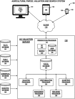
1. A method for agricultural land parcel valuation, the method comprising:
accessing data corresponding to each of a plurality of parcels within a prescribed region, the data comprising corresponding management practices, corresponding historical weather conditions, corresponding locations and topography, corresponding remote sense images, corresponding soil types, and corresponding crop types;
assessing and ranking the corresponding management practices for the each of the plurality of parcels;
generating simulation inputs for the each of the plurality of parcels, wherein the simulation inputs comprise highest ranked corresponding management practices, the corresponding historical weather conditions, the corresponding locations and topography, the corresponding soil types, and the corresponding crop types;
simulating crop growth for the each of the plurality of parcels over a prescribed number of previous years, wherein said simulating employs the simulation inputs provided by said generating;
employing selected outputs from said simulating to calculate agricultural metrics and a valuation corresponding to the each of the plurality of parcels, wherein the valuation for the each of the plurality of parcels is expressed relative to all of the plurality of parcels within the prescribed region, the agricultural metrics comprising a sustainability metric and a stability metric, and wherein the sustainability metric comprises a function of an average of yearly sustainability component values, and wherein said yearly sustainability component values comprise yearly nitrogen leaching scores and yearly greenhouse gas emissions scores, and wherein said yearly nitrogen leaching scores and said yearly greenhouse gas emissions scores are calculated based upon outputs of said simulating crop growth for a corresponding year, and wherein a processor combines best yearly vegetative index images according to a stability (HMLU) algorithm into a single HMLU image and then calculates the stability metric comprising a fraction of the single HMLU image that comprises high-stability and medium-stability pixels;
storing the agricultural metrics and the valuation corresponding to the each of the plurality of parcels in corresponding database records; and
via a communications circuit disposed within a server;
receiving search inputs from a client device; and
responsive to reception of the search inputs, transmitting one or more of the corresponding database records that satisfy the search inputs to the client deice.
|