| CPC G06F 16/288 (2019.01) [G06F 16/212 (2019.01); G06F 16/2272 (2019.01); G06F 16/244 (2019.01); G06F 16/29 (2019.01); G06N 20/00 (2019.01); G06V 10/44 (2022.01); G06V 20/13 (2022.01)] | 4 Claims |
|
1. A computing device for storing and analyzing geospatial data comprising:
an interface to a repository of geospatial data sets, each geospatial data set defining a data parameter correlated to a geographic entity;
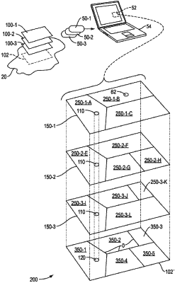
an application for determining, for each of a plurality of geospatial data sets received from the interface, a plurality of subregions, each subregion corresponding to a portion of the geographic entity having the same value for the data parameter defined by the respective geospatial data set;
a memory responsive to the application for arranging the geospatial data sets into layers, each layer defining the data parameter for the respective subregions of the geographic entity and having a corresponding value on the other layers of the plurality of layers for a geographic location within the geographic entity;
the application including instructions for subdividing the geographic entity into a plurality of polygons, each polygon defining an area of the geographic entity for which values of each layer are invariant;
a repository for storing, for each polygon, the value of the data parameter defined by each layer for the area within the polygon; and
a user interface for receiving a query indicative of an aggregate result for a location in the geographic entity, the application responsive to the query for identifying one or more polygon of the plurality of polygons corresponding to the location and computing a result based on traversal of the identified polygons.
|