| CPC G06F 3/04842 (2013.01) [G06F 16/9537 (2019.01); G06F 40/205 (2020.01); G06F 40/284 (2020.01); G06F 3/0483 (2013.01)] | 18 Claims |
|
1. A method of visual analysis of datasets, comprising:
at a computing system having one or more processors and memory storing one or more programs configured for execution by the one or more processors:
receiving user selection of a data source;
presenting a natural language interface for analysis of data in the selected data source;
in response to receiving a first user input to specify an incomplete natural language command directed to the data source:
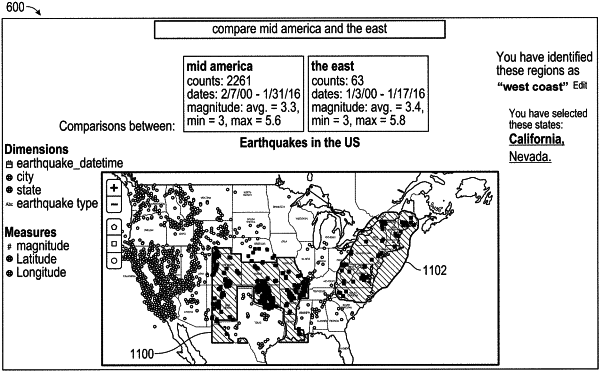
presenting a map widget for selecting geospatial data points from the data source;
receiving a second user input that visually constructs a user-defined region in a map included in the map widget, wherein the map includes a plurality of predetermined geographic regions;
generating a coverage metric for each of the plurality of predetermined geographic regions that helps users assess and refine spatial queries using the plurality of predetermined geographic regions as well as data characteristics, wherein the coverage metric represents a confidence level of selecting a particular predetermined geographic region and the coverage metric is computed based on (1) a proportion of data points included in the user-defined region for a respective geographic region from a total number of data points in the respective geographic region and (2) a proportion of the respective geographic region that overlaps with the user-defined region;
selecting one or more of the predetermined geographic regions based on the generated coverage metric for each of the plurality of predetermined geographic regions;
completing the natural language command with the selected one or more predetermined geographic regions; and
generating and displaying a map data visualization according to the completed natural language command.
|