| CPC G05D 1/0274 (2013.01) [G05D 1/0214 (2013.01); G06T 7/11 (2017.01); G06T 7/136 (2017.01); G06T 7/60 (2013.01); G06T 7/73 (2017.01); G06T 2207/20044 (2013.01)] | 5 Claims |
|
1. A path planning method of mobile robots based on image processing, comprising:
preprocessing of a map image: calculating a safety distance s between a mobile robot and a surrounding obstacle during a movement of the mobile robot based on external geometric features of the mobile robot, forming a circular range on the map image with a boundary point of the obstacle as a center and the safety distance s as a expansion radius to set a safety range, and marking the safety range; performing skeleton feature extraction on the map image after the marking to obtain a reference path map;
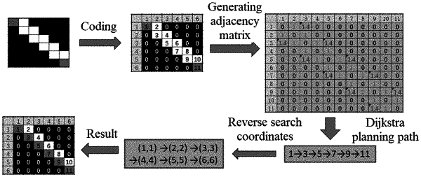
obtaining of an initial path: building an adjacency matrix, and performing path solution on the reference path map based on the adjacency matrix to obtain the initial path;
optimizing the initial path:
performing neighborhood expansion on the initial path to obtain an expansion path;
performing segmentation on the expansion path to obtain n numbers of segmented paths, and optimizing the n numbers of segmented paths separately;
splicing the n numbers of segmented paths after the optimizing to obtain an optimized full path;
wherein the performing segmentation on the expansion path to obtain n numbers of segmented paths, and optimizing the n numbers of segmented paths separately, comprises:
determining a segment length cd of each of the n numbers of segmented paths;
searching each of path points on the initial path and obtaining coordinates of the path points in each the segmented path;
calculating minimum and maximum values of horizontal and vertical coordinates in coordinate points, respectively, for each the segmented path, and the minimum and maximum values being denoted as: [imin:imax, jmin:jmax];
calculating a size of an area to be extracted by imin, imax, jmin, jmax;
w=imax−imin+1;
l=jmax−jmin+1;
where w is a width of an extracted area, and l is a length of the extracted area;
the extracted area for each the segmented path being: [imin:imax, jmin:jmax];
building an adjacency matrix for each the segmented path;
optimizing each the segmented path; and
obtaining an optimization result for the n numbers of segmented paths;
wherein the path planning method further comprises: controlling a mobile robot to move along the optimized full path.
|