US 11,719,853 B2
Underground infrastructure sensing using unmanned aerial vehicle (UAV)
Justin Starr, Baden, PA (US); Galin Konakchiev, Pittsburgh, PA (US); Foster J Salotti, Verona, PA (US); Mark Jordan, Pittsburgh, PA (US); Nate Alford, North Huntington, PA (US); Thorin Tobiassen, Pittsburgh, PA (US); Todd Kueny, Tarentum, PA (US); and Jason Mizgorski, Gibsonia, PA (US)
Assigned to RedZone Robotics, Inc., Warrendale, PA (US)
Filed by RedZone Robotics, Inc., Warrendale, PA (US)
Filed on Sep. 13, 2021, as Appl. No. 17/473,949.
Application 17/473,949 is a continuation of application No. 16/184,054, filed on Nov. 8, 2018, granted, now 11,125,910.
Claims priority of provisional application 62/583,689, filed on Nov. 9, 2017.
Prior Publication US 2021/0405244 A1, Dec. 30, 2021
This patent is subject to a terminal disclaimer.
Int. Cl. G01S 13/88 (2006.01); G01S 7/41 (2006.01); G01S 13/90 (2006.01); G01V 11/00 (2006.01); G05D 1/00 (2006.01); G01V 8/02 (2006.01); B64C 39/02 (2023.01); B64U 101/00 (2023.01)
CPC G01V 11/002 (2013.01) [B64C 39/024 (2013.01); G01S 7/412 (2013.01); G01S 13/885 (2013.01); G01V 8/02 (2013.01); G05D 1/0094 (2013.01); B64U 2101/00 (2023.01); G01S 13/90 (2013.01)] 20 Claims
OG exemplary drawing
 
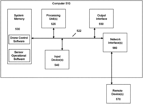
1. A method, comprising:
obtaining sensor data from a ground penetrating radar (GPR) unit;
analyzing, using a processor, the sensor data to detect a first object and a second object, the second object being associated with the first object based on location;
identifying, with the processor, an underground pipe feature based on the analyzing;
associating a position of the underground pipe feature with a location in a pipe network;
selecting a subset of the pipe network including a pipe segment associated with the position of the underground pipe feature; and
providing the subset of the pipe network as displayable data to a display device.