| CPC G01V 1/50 (2013.01) [G01V 1/22 (2013.01); G01V 1/306 (2013.01); G06N 5/022 (2013.01); G06N 7/00 (2013.01); G06N 20/00 (2019.01)] | 16 Claims |
|
1. A computer system including a machine learning platform to perform sweet spotting, the computer system comprising:
a processor set; and
a computer readable storage medium;
wherein:
the processor set is structured, located, connected, and/or programmed to run program instructions stored on the computer readable storage medium; and
the program instructions which, when executed by the processor set, cause the processor set to perform a method comprising:
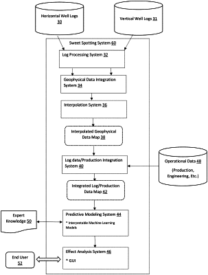
collecting geophysical measurements from horizontal well logs and vertical well logs and production information from the horizontal well logs;
extracting geological measurements from the geophysical measurements and removing outliers from the geological measurements;
integrating feature data from horizontal well logs and vertical well logs to form a set of integrated feature data by:
identifying extracted geological measurements around a vertical well;
summarizing the extracted geological measurements with a set of representative vertical values including moments and empirical quantiles of a distribution;
performing a down sampling of a smoothing approximation of the extracted geological measurements and the production information of a horizontal well to obtain a set of representative horizontal values across a path of the horizontal well; and
joining the set of representative vertical values and the set of representative horizontal values to create the set of integrated feature data;
generating a data map by interpolating the set of integrated feature data, the data map being continuous over a region of interest such that each data point of the set of integrated feature data is associated with at least one data value;
integrating operational data into the data map to generate a machine-learning (ML) data map;
generating, by an interpretable machine learning model, a function based on the ML data map, wherein the data map includes geophysical data and operational data over a region of interest, and wherein the function relates a set of predictive variables to one or more response variables;
evaluating the function to identify one or more sweet spots at unique points in the region of interest; and
generating a GUI for displaying and modifying the function.
|