| CPC B60W 50/14 (2013.01) [B60W 10/20 (2013.01); G01S 7/003 (2013.01); G01S 17/89 (2013.01); G01S 17/931 (2020.01); G05D 1/0094 (2013.01); G05D 1/0248 (2013.01); G06T 7/74 (2017.01); G06V 10/774 (2022.01); G06V 10/776 (2022.01); G06V 10/806 (2022.01); G06V 20/56 (2022.01); G06V 20/647 (2022.01); B60W 2420/42 (2013.01); B60W 2420/52 (2013.01); G06T 2207/30244 (2013.01); G06T 2210/12 (2013.01)] | 20 Claims |
|
1. A method of generating and applying driving data to an autonomous driving system, the method comprising:
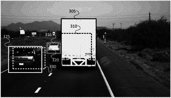
determining three-dimensional bounding indicators for one or more first objects in road target information captured by a light detection and ranging (LIDAR) sensor located on a first vehicle;
determining camera bounding indicators for one or more second objects in road image information captured by a camera sensor located on a second vehicle, wherein the road target information is captured by the LIDAR sensor on the first vehicle and the road image information is captured by the camera sensor on the second vehicle as the first vehicle and the second vehicle are operating on a road and having a distance in between the first vehicle and the second vehicle;
processing the road image information to generate a camera matrix;
determining projected bounding indicators from the camera matrix and the three-dimensional bounding indicators;
determining, from the projected bounding indicators and the camera bounding indicators, associations between the one or more first objects and the one or more second objects to generate a combined target information, wherein the projected bounding indicators and the camera bounding indicators are two-dimensional, wherein the combined target information comprises data that is generated based on the association of the projected bounding indicators with the camera bounding indicators; and
applying, by the autonomous driving system, the combined target information to produce a vehicle control signal.
|