| CPC G06T 7/521 (2017.01) [G06T 3/60 (2013.01); G06T 7/13 (2017.01); G06T 7/20 (2013.01); G06T 7/70 (2017.01); G06T 2207/10028 (2013.01); G06T 2207/30252 (2013.01)] | 15 Claims |
|
1. A computer-implemented method for determining a shape descriptor of point cloud data in an automotive system for monitoring the environment of a vehicle, the shape descriptor being indicative of the shape of the point cloud data, the point cloud data being generated by one or more sensors of the vehicle with respect to a reference coordinate system, the point cloud data defining a connected subspace of the reference coordinate system, the method comprising the steps:
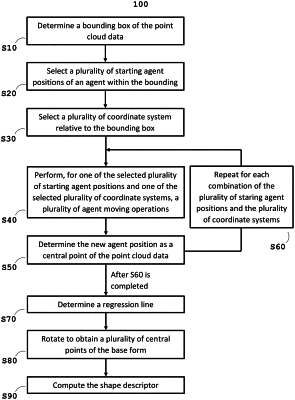
a) determining (S10) a bounding box of the point cloud data;
b) selecting (S20) a plurality of starting agent positions of an agent within the bounding box;
c) selecting (S30) a plurality of coordinate systems relative to the bounding box;
d) performing (S40), for one of the selected plurality of starting agent positions and one of the selected plurality of coordinate systems, a plurality of agent moving operations, wherein each agent moving operation comprises moving the agent from the current agent position to a new agent position parallel to a coordinate axis of the selected coordinate system, wherein the new agent position is determined based on an intersecting line through the current agent position parallel to the coordinate axis;
e) determining, after step d) is completed, the new agent position as a central point of the point cloud data;
f) repeating (S60) steps d) and e) for each combination of the plurality of staring agent positions and the plurality of coordinate systems, thereby determining a plurality of central points of the point cloud data;
g) determining (S70) a regression line by calculating a linear regression for the plurality of central points;
h) performing (S80) one of the following steps h1) and h2):
h1) rotating (S81) the plurality of central points to a base form such that the regression line corresponds to a predetermined direction; or
h2) rotating (S82) the point cloud data to a base form such that the regression line corresponds to a predetermined direction, and repeating steps a) to f) for the base form to obtain a plurality of central points of the base form;
i) computing (S90) the shape descriptor based on the plurality of central points of the base form, wherein the shape descriptor comprises the one or more inclination angles and information indicative of the stretch and compression of the base form of the point cloud data with respect to one or more axis of the reference coordinate system.
|