| CPC G05D 1/0212 (2013.01) [B60W 60/001 (2020.02); G01C 21/188 (2020.08); G01C 21/30 (2013.01); G05D 1/0088 (2013.01); B60W 2420/42 (2013.01); B60W 2420/52 (2013.01); B60W 2420/54 (2013.01); G05D 1/0248 (2013.01); G05D 1/0255 (2013.01); G05D 1/0257 (2013.01)] | 24 Claims |
|
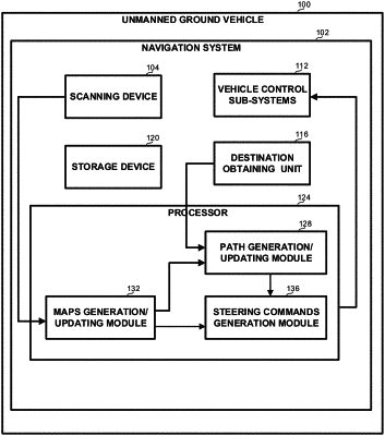
12. A system mountable on a vehicle, comprising:
a scanning device configured to repeatedly scan an area surrounding the vehicle, to thereby provide scanning output data indicative of distances between objects in the area and the vehicle in a multiplicity of directions;
an Inertial Navigation System (INS for providing data indicative of a current location of the vehicle relative to a previous location;
one or more computer processors configured to:
generate, based on the scanning output data a first map representing at least a part of the area and characterized by a first map size; wherein the map comprises a first group of cells characterized a first cell size which is equal or larger than an accumulated drift value of the INS over a first predefined distance which is related to the first map size;
generate, based on the scanning output, a second map representing a part of the area and characterized by a second map size, which is smaller than the first map size; wherein the map comprises a second group of cells characterized by a second cell size, smaller than the first cell size;
wherein the second map at least partly overlaps the first map and wherein cells in the first group of cells and the second group of cells are classified to a class selected from at least two classes, comprising traversable and non-traversable and wherein non-traversable cells in the first map and the second map indicate obstacles;
generate deduced data by crossing between information about one or more cells in the first group of cells and about one or more cells in the second group of cells; wherein the deduced data provides a more accurate indication about size of obstacles located within the area;
receive INS data from the INS that is indicative of a current location of the vehicle relative to a previous location; and
generate navigation instructions for leading the vehicle through the area while avoiding obstacles, based on the INS data and the deduced data.
|