| CPC G06Q 50/165 (2013.01) [G06F 16/29 (2019.01); G06Q 50/163 (2013.01)] | 20 Claims |
|
1. A computer-implemented method comprising:
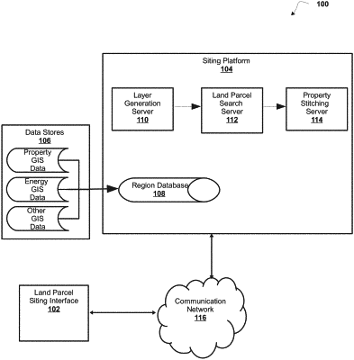
providing a sitting interface, by a siting system comprising one or more processors, the sitting interface including a plurality of selectable proximity factors for generating a new land parcel within a requested region, for land development siting from one or more selectable proximity factors;
determining, with the one or more processors, at least one primary land parcel for a primary site selection which includes a land parcel size below a requested sizing threshold based on information received from a geographical information system (GIS), the GIS information including land parcel data defining a plurality of land parcels and energy data defining a plurality of energy infrastructures in at least one of the plurality of land parcels;
activating a request for one or more secondary site selections to fulfill the primary site selection sizing requirement automatically determining, with the one or more processors, a siting buffer of the primary land parcel that indicates a secondary site selection within proximity of an energy infrastructure of the plurality of energy infrastructures, the siting buffer adapted to include a number of buffer rings, each comprising a proximity score, based on an importance factor of the energy infrastructure, the proximity score, based on least a part of an objective score associated with features of the plurality of land parcels based on at least one of a size, a type, a slope, or a proximity of a land parcel;
and
providing a land parcel scoring interface, by a mobile device, representing a new site selection response based on scores adapted from the siting buffer to stitch the at least one primary land parcel to at least one secondary land parcel, wherein a site selection response with the at least one secondary land parcel within a preferred proximity is not in a first ring of the siting buffer, and in response, the new site selection response is generated to include the at least one secondary land parcel based on the importance factor of the siting buffer.
|