| CPC G06F 30/12 (2020.01) [G01V 1/50 (2013.01); G06T 17/05 (2013.01)] | 8 Claims |
|
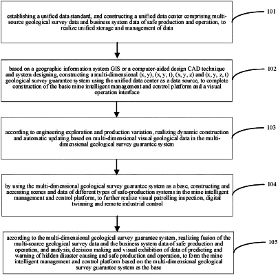
1. A construction method of an advanced mine intelligent management and control platform based on a geological survey guarantee system, wherein the construction method comprises steps of:
step 1: establishing a unified data standard, and constructing a unified data center comprising multi-source geological survey data and business system data of safe production and operation, to implement unified storage and management of data;
step 2: constructing a multi-dimensional (x, y), (x, y, t), (x, y, z) and (x, y, z, t) geological survey guarantee system which uses the unified data center as a data source based on a geographic information system (GIS) or computer-aided design (CAD) technique and system, to complete construction of a basic mine intelligent management and control platform and a visual operation interface;
step 3: according to engineering exploration and production variation, performing dynamic construction and automatic updating based on multi-dimensional visual geological survey data in the multi-dimensional geological survey guarantee system;
step 4: by using the multi-dimensional geological survey guarantee system as a base, constructing and accessing scenes and data of different types of safe-production systems in the basic mine intelligent management and control platform, to implement visualized patrolling inspection, digital twinning and remote industrial control; and
step 5: according to the multi-dimensional geological survey guarantee system, performing fusion of the multi-source geological survey data and the business system data of safe production and operation, and analysis, decision making and visual exhibition of data of hidden disaster causing and safe production and operation, to form the advanced mine intelligent management and control platform by using the multi-dimensional geological survey guarantee system as the base;
wherein the multi-source geological survey data comprise: geological survey information that reflects a geographic-coordinate location and is provided with a multi-dimensional geographic-coordinate feature;
the multi-source geological survey data are basic geographical and space-time information for ensuring normal exploitation of a mine, and is provided with a multi-dimensional geographic-coordinate feature, and with data-presentation forms comprising (x, y), (x, y, t), (x, y, z) and (x, y, z, t);
the geographic-coordinate location is a spatial position that is capable of reflecting a location of a geological body, and describes a spatial position between the geological body and a laneway and a working face by using a coordinate system, and in the multi-dimensional (x, y), (x, y, t), (x, y, z) and (x, y, z, t) geological survey guarantee system, x represents a horizontal coordinate describing the geological body based on the coordinate system, y represents a vertical coordinate describing the geological body based on the coordinate system, and z represents an attribute value comprising an elevation or a stratum thickness describing the geological body based on the coordinate system, wherein t represents time information;
the step of constructing the multi-dimensional (x, y), (x, y, t), (x, y, z) and (x, y, z, t) geological survey guarantee system which uses the unified data center as the data source, to construct the basic mine intelligent management and control platform comprises:
based on the multi-dimensional geographic-coordinate feature, designing and constructing the multi-dimensional geological survey guarantee system by using the GIS or the CAD technique and system, wherein the multi-dimensional geological survey guarantee system exhibits in a two-dimensional, three-dimensional or four-dimensional mode;
in the construction of the basic mine intelligent management and control platform, the basic platform uses complete basic geological survey information and results of data processing and analysis in the multi-dimensional geological survey guarantee system as a basis for storage and exhibition of the basic mine intelligent management and control platform, wherein the complete basic geological survey information refers to geological data and measurement data having multi-dimensional geographic coordinates, the geological data refer to survey data including coal bed, terrane, aquiclude, mine pressure and gas, geological structure and results of working-face coal-terrane identification that are acquired by exploratory boring, geophysical prospecting, chemical exploration and laneway sketching;
the measurement data refer to surveying-and-mapping data of earth surface, laneway, working face and goaf that are formed by engineering construction in a process of mine construction;
the results of data processing and analysis refer to morphologies and characteristics of coal bed or stratum and conditions of spatial distribution of laneway, geological reserve, construction, hydrology, gas, mine pressure and rock-or-stratum physical-property parameter that are obtained by processing and professional analysis on the basic geological survey information;
the visual operation interface displays the complete basic geological survey information and the results of data processing and analysis on a screen by using the GIS or CAD technique, and is capable of operating a displayed interface;
a mode of a visualization comprises a two-dimensional mode, a three-dimensional mode and a four-dimensional mode, and the operating refers to interaction with the multi-dimensional basic geological survey information and the results of data processing and analysis in the visual interface by using a mouse, a keyboard, screen touching and voice controlling;
a geological-guarantee function comprises: storing, exhibiting, inquiring and operating spatial distribution of laneways, coal beds and other stratums, and an abnormal region and an abnormal value, and exhibiting essential information and abnormal information of stope faces and driving working faces, wherein the abnormal region refers to a region where mine pressure, gas or hydrology is abnormal or a region where a coal bed is provided with a characteristic of spontaneous combustion;
the multi-dimensional geological survey guarantee system is provided with basic features comprising a system-architecture-mode feature, an essential-information-exhibition feature, and a time-space analysis-and-application feature;
the system-architecture-mode feature refers to that an architecture of the multi-dimensional geological survey guarantee system supports architectures of B/S and C/S, and satisfies a mode of cloud deployment;
the essential-information-exhibition feature refers to that the multi-dimensional geological survey guarantee system implements visual exhibition of the multi-source geological survey data, comprising: coal-bed information, coal-bed-spontaneous-combustion feature information, drilling information, fault information, laneway information, pools-zone information, goaf information, collapse-column information, and gas-and-mine-pressure abnormal-region information, and a mode of the exhibition comprises a two-dimensional mode, a three-dimensional mode and a four-dimensional mode;
the time-space analysis-and-application feature refers to that the multi-dimensional geological survey guarantee system performs visual exhibition and inquiring of abnormal regions and abnormal values of mine pressure, gas, hydrology, and characteristic of spontaneous combustion of coal bed, exhibits the essential information and the abnormal information of the stope faces and the driving working faces, and is capable of exhibiting coal-mine stratum, geological structure, coal bed, coal quality, gas, hydrogeology and other geological conditions, geological features and change rules based on a geological survey model and an engineering-data model; and
the multi-dimensional geological survey guarantee system is provided with relevant geological-survey-guarantee-type functions of high-precision geological modeling, laneway modeling, transparent working face, three-dimensional-space-information analysis and historical-data consulting, and hidden-disaster-causing analysis, wherein the hidden-disaster-causing analysis refers to performing predicting and warning analysis on mine hazard sources and disaster data.
|