| CPC G01C 22/00 (2013.01) [G01S 19/10 (2013.01); G01S 19/14 (2013.01); G01S 19/20 (2013.01); G01S 19/252 (2013.01)] | 2 Claims |
|
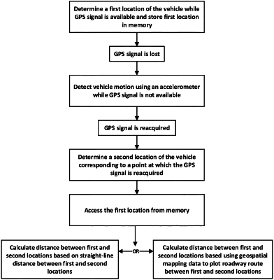
1. A method for compensating for the absence of GPS data during a period of GPS signal loss in determining travel mileage of a vehicle, comprising:
a GPS receiver of a GPS device in the vehicle determining a first location of the vehicle based on a GPS signal while the GPS signal is available;
storing the first location in memory of the GPS device;
detecting vehicle motion using an accelerometer in the vehicle during a period of time in which the GPS receiver is unable to determine a location of the vehicle due to loss of the GPS signal;
based on detection of motion using the accelerometer, accessing from the memory the first location corresponding to a last known GPS location of the vehicle;
the GPS receiver reacquiring the GPS signal and determining, based on the GPS signal, a second location of the vehicle corresponding to a point at which the GPS signal is reacquired; and
the GPS device calculating the distance between the first and second locations to determine travel mileage of the vehicle during the period of GPS signal loss, the calculating based on:
a straight-line distance calculation between the first and second locations; or
using geospatial mapping data to plot a roadway route between the first and second locations.
|