| CPC G01C 21/3848 (2020.08) [G01C 21/3826 (2020.08); G01S 19/42 (2013.01); G05D 1/0011 (2013.01); G05D 1/0212 (2013.01); G05D 1/0227 (2013.01); G06V 20/188 (2022.01)] | 19 Claims |
|
10. A method implemented by one or more processors, the method comprising:
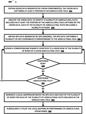
obtaining driving data generated during an episode of locomotion of a vehicle through an agricultural field, the agricultural field including a plurality rows, the vehicle including one or more GPS sensors, and the vehicle being driven manually by a user or being driven autonomously according to a robotic control policy;
during the episode of locomotion of the vehicle and prior to generating a local mapping of the agricultural field, and for each of the plurality of rows:
identifying, based on the driving data, a trajectory of the vehicle during the episode of locomotion of the vehicle;
obtaining GPS data generated by one or more of the GPS sensors of the vehicle, the GPS data capturing GPS coordinates corresponding to the agricultural field and along the identified trajectory;
associating the GPS data along the identified trajectory with a given row of the plurality of rows; and
assigning a corresponding semantic identifier to the given row;
generating the local mapping, the local mapping being between the GPS data and each of the plurality of rows in the agricultural field, and the local mapping including the corresponding semantic identifier assigned to each of the plurality of rows during the episode of locomotion; and
subsequent to generating the local mapping:
causing the local mapping to be utilized in performance of one or more agricultural operations, wherein causing the local mapping to be utilized in performance of one or more of the agricultural operations comprises:
causing vision data that is generated by one or more vision components to be obtained, the vision data capturing at least a portion of the agricultural field;
causing the vision data to be analyzed to identify an event associated with at least one crop of at least one row of the plurality of rows;
causing a notification to be generated based on the identified event associated with the at least one row and based on the local mapping; and
causing the notification to be rendered at a client device of a user.
|