| CPC B60W 60/0015 (2020.02) [B60W 30/09 (2013.01); B60W 30/0956 (2013.01); G01C 21/3461 (2013.01); G01S 19/42 (2013.01); G01S 19/425 (2013.01); G01S 19/46 (2013.01); G01S 19/485 (2020.05); B60W 2420/42 (2013.01); B60W 2420/52 (2013.01); B60W 2554/20 (2020.02); B60W 2554/40 (2020.02)] | 18 Claims |
|
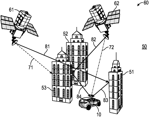
1. A computer implemented method for navigating a mobile platform in an environment, comprising:
obtaining, by a processor, information about at least one object in the environment based on received data from the environment;
obtaining, by the processor, information about a first satellite;
estimating, by the processor, a probability indicator of a non-line of sight signal transmission between a current satellite location of the first satellite and a current location of the mobile platform, wherein the probability indicator is estimated using the information about the first satellite and the information about the at least one object;
determining, by the processor, a discrepancy indicator using a movement information of the mobile platform and a movement information of the first satellite, wherein discrepancy indicator is representative for an inaccuracy in signal transmission between the first satellite and the mobile platform;
determining, by the processor, a weighting indicator using the estimated probability indicator and the determined discrepancy indicator;
assigning, by the processor, the determined weighting indicator to a satellite signal transmitted from the first satellite in order to provide a first weighted signal; and
controlling the mobile platform based on the first weighted signal,
wherein obtaining information about the first satellite includes processing information about a determined location of the first satellite;
wherein the method further comprises:
determining, by the processor, a plurality of sample locations of the mobile platform in the environment,
wherein the probability indicator is estimated using the determined location of the first satellite and the plurality of sample locations of the mobile platform,
wherein estimating the probability indicator includes:
obtaining, by a camera, an image of the environment of the mobile platform, wherein the image includes the at least one object;
determining, by the processor, a plurality of sample locations of the first satellite using the sample locations of the mobile platform in the environment and a characteristic of the camera;
determining, by the processor, a plurality of points in the image that correspond to the plurality of sample locations of the first satellite by projecting the plurality of point into the image; and
estimating, by the processor, the probability indicator based on a relative position of the plurality of points in the image with respect to the at least one object within the image.
|