| CPC H04W 16/18 (2013.01) [G01S 13/865 (2013.01); G01S 13/89 (2013.01); G06V 10/803 (2022.01); G06V 20/13 (2022.01); H04B 7/0473 (2013.01); H04W 76/15 (2018.02); B60W 2420/42 (2013.01); G01S 17/88 (2013.01); G01S 17/89 (2013.01); G01S 17/931 (2020.01); G05D 1/0088 (2013.01); G05D 2201/0213 (2013.01)] | 20 Claims |
|
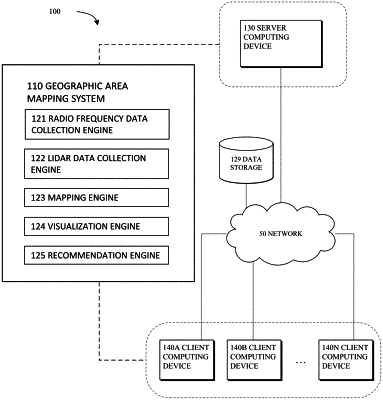
1. A method for mapping a geographic area, comprising:
collecting, from a set of mobile devices, radio frequency data, the radio frequency data comprising information about a set of network connections in the geographic area;
collecting lidar data for the geographic area;
generating a mapping between the collected radio frequency data and the collected lidar data for the geographic area;
providing a visualization of the mapped radio frequency data and lidar data for the geographic area;
predicting, based on the collected radio frequency data and the collected lidar data, that a network event is going to occur; and
providing an alert related to the predicted network event.
|