| CPC H04W 4/029 (2018.02) [G01S 5/12 (2013.01); H04L 5/0048 (2013.01); H04W 4/44 (2018.02)] | 24 Claims |
|
1. A method for wireless communications by a user equipment (UE), comprising:
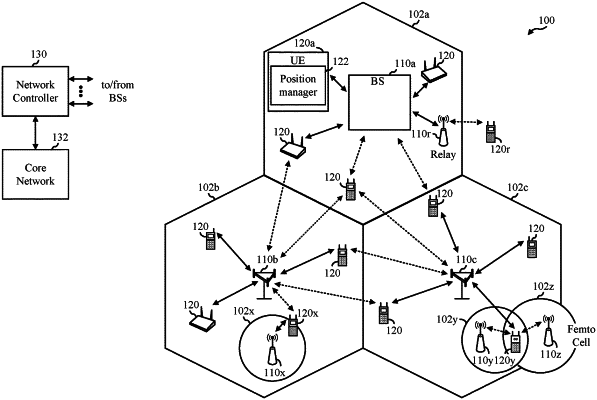
obtaining map information regarding, at least, one or more reflectors in an environment including at least the UE and a node;
transmitting a positioning reference signal (PRS) transmission, wherein multiple instances of the PRS transmission travel on different transmission paths between the UE and the node;
receiving an indication of arrival times of the multiple instances of the PRS transmission at the node;
detecting, based on the arrival times, that one of the multiple instances of the PRS transmission travels a non line-of-sight (NLOS) transmission path in the environment;
participating in a positioning procedure that estimates a position of the UE based, at least in part, on the one of the multiple instances of the PRS transmission that travels the NLOS transmission path and the map information;
measuring arrival times of multiple instances of a same PRS transmission received by the UE from the node or another node, wherein the same PRS transmission is received on two or more transmission paths between the UE and the node or the other node; and
broadcasting the arrival times of the multiple instances of the same PRS transmission, based on availability of the map information.
|