| CPC G06T 3/4007 (2013.01) [A01D 41/127 (2013.01); G06N 3/047 (2023.01); G06N 3/08 (2013.01); G06Q 10/04 (2013.01); G06Q 50/02 (2013.01); G06T 5/50 (2013.01); G06T 7/0016 (2013.01); G06T 7/143 (2017.01); G06V 10/82 (2022.01); G06V 20/13 (2022.01); G06V 20/188 (2022.01); G06T 2207/10016 (2013.01); G06T 2207/10032 (2013.01); G06T 2207/10048 (2013.01); G06T 2207/20081 (2013.01); G06T 2207/20084 (2013.01); G06T 2207/20221 (2013.01); G06T 2207/30181 (2013.01); G06T 2207/30188 (2013.01); G06V 20/194 (2022.01)] | 18 Claims |
|
1. A method implemented using one or more processors, comprising:
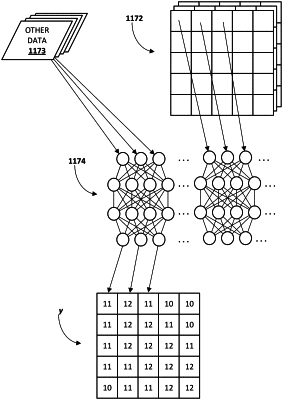
obtaining a first temporal sequence of high-elevation digital images, wherein the first temporal sequence of high-elevation digital images capture a first geographic area and are acquired over a first predetermined time interval, and wherein during the first predetermined time interval, the first geographic area includes a first type of crop;
obtaining a first plurality of other data points, wherein the first plurality of other data points influence a ground truth crop yield of the first geographic area after the first predetermined time interval, and wherein the first plurality of other data points are grouped into temporal chunks, each temporal chunk of the first plurality of other data points corresponding temporally with a respective high-elevation digital image of the first temporal sequence of high-elevation digital images;
iteratively applying individual pixel values of the high-elevation digital images of the first temporal sequence and the temporal chunks of the first plurality of other data points directly as input across a trained recurrent neural network to generate first output, wherein the first output comprises a plurality of crop-yield predictions for a plurality of geographic units of the geographic area at the end of the first predetermined time interval, wherein the plurality of geographic units correspond spatially to pixels of the first temporal sequence of high-elevation digital images; and
causing one or more output components of one or more computing devices to audibly or visually convey data indicative of the first output.
|