| CPC G08G 5/065 (2013.01) [G08G 5/0026 (2013.01); G08G 5/0043 (2013.01); G10L 15/22 (2013.01); G10L 15/26 (2013.01)] | 13 Claims |
|
1. A system for contextual alerts during ground operations, comprising:
a source of airport feature data associated with an airport field;
a source of navigation data including a current location and heading of an aircraft;
a source of an assigned runway;
a problematic scenarios database comprising predefined problematic geometries and scenarios;
a source of traffic data;
a display device; and
a control module operationally coupled to the source of airport feature data, the source of navigation data, the source of the assigned runway, the problematic scenarios database, the display device, and the source of traffic data, the control module configured to:
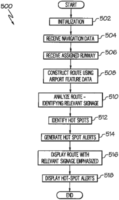
receive the assigned runway;
construct, using airport feature data, a route for the aircraft to travel from its current location to the assigned runway, the route including a travel direction;
receive a temporal problem scenario from an external source;
identify a temporal hot-spot on the route when the temporal problem scenario is on the route;
cause the display device to render an image showing the aircraft at the current location and heading on the airport field on the display system;
analyze the route to identify relevant signage features, defined as signage features associated with the route;
cause the display device to render the relevant signage features on the image with a visual emphasis that provides visual distinguishability with respect to remaining signage features in the image;
cause the display device to display a traffic hot-spot alert at a location on the route in which a traffic is currently causing congestion, while the traffic is causing congestion at the location on the route;
cause the display device to display a design hot-spot alert on the image when an area on the route includes at least one predefined problematic geometry or scenario; and
cause the display device to display a temporal hot-spot alert when the temporal hot-spot is identified,
wherein the traffic hot-spot alert, the design hot-spot alert, and the temporal hot-spot alert are each visually distinguishable from each other, and
wherein the temporal problem scenario includes one or more of (i) a temporary closure of all or a portion of a runway or taxiway, (ii) using both ends of a runway for takeoff or landing, and (iii) temporary enabling or disabling of rapid exit taxiways.
|