| CPC G08G 5/025 (2013.01) [B64C 29/0025 (2013.01); B64D 47/08 (2013.01); G06T 3/40 (2013.01); G06T 3/60 (2013.01); G06T 7/70 (2017.01); G06T 11/00 (2013.01)] | 20 Claims |
|
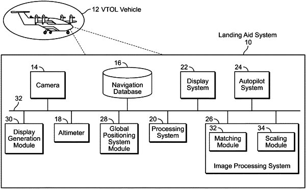
1. A vertical takeoff and landing, VTOL, vehicle comprising:
an image capture device;
an altimeter;
a database storing template landing pad image data for at least one template landing pad; and
at least one processor in operable communication with the image capture device, the database and the altimeter, wherein the at least one processor is configured to:
receive image data from the image capture device;
receive altitude data from the altimeter;
retrieve template landing pad image data for a target landing pad from the database;
scale the template landing pad image data based on the altitude data using a scaling algorithm that determines a scaling parameter in proportion to a relative height of the VTOL vehicle above the target landing pad and multiplies dimensions of the template landing image data by the scaling parameter so that the template landing image data is proportionally transformed to a larger size as the relative height is reduced, wherein the relative height is determined based on the altitude data;
compare the scaled template landing pad image data and the image data received from the image capture device to locate the target landing pad therein using a comparison algorithm that searches image space of the image data received from the image capture device to find a match for the scaled template landing pad image data, thereby providing target landing pad localization data; and
control a function of the VTOL vehicle based on the target landing pad localization data.
|