| CPC G06T 11/60 (2013.01) [G06F 3/04817 (2013.01); H04W 4/021 (2013.01); G01S 19/13 (2013.01); G06F 2203/04806 (2013.01); G06T 2200/24 (2013.01)] | 20 Claims |
|
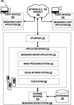
1. A method comprising:
determining a geographic location of the client device based on location data from one or more sensors of the client device;
displaying a map on a display device of a client device;
determining a zoom level of the displayed map;
determining that a geographic location of an icon is located within the displayed map;
identifying a first geo-fence area of the icon based on the geographic location of the icon, the first geo-fence area corresponding to a display of the icon on the displayed map;
identifying a second geo-fence area of the icon based on the geographic location of the icon, the second geo-fence area corresponding to unlocked access to content associated with the icon;
determining a state of the icon based on the zoom level of the displayed map, the geographic location of the client device relative to the first geo-fence area of the icon, and the geographic location of the client device relative to the second geo-fence area of the icon;
determining whether to display the icon in the displayed map based on the state of the icon; and
determining whether to unlock access to content associated with the icon based on the state of the icon.
|