| CPC G06F 3/0484 (2013.01) [G06F 3/0481 (2013.01); G06F 3/0482 (2013.01); G06F 3/04817 (2013.01); G06F 16/29 (2019.01); G06Q 10/06 (2013.01); G06Q 50/26 (2013.01); G06Q 50/265 (2013.01); G09B 29/006 (2013.01); H04W 4/90 (2018.02); G06F 2203/04806 (2013.01); H04M 3/5133 (2013.01); H04M 2201/42 (2013.01); H04M 2242/04 (2013.01)] | 20 Claims |
|
1. A computer system configured to provide a dynamic user interface relating to visualizations of data associated with a law enforcement agency, the computer system comprising:
one or more hardware computer processors configured to execute code to cause the computer system to:
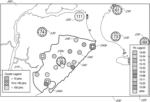
generate a dynamic user interface including an interactive geographical map, the map including a first plurality of selectable indicators each associated with respective predetermined geographical regions, wherein an appearance of each of the first plurality of selectable indicators is based on quantities of events associated with the respective associated predetermined geographical regions, the events determined from data associated with a law enforcement agency;
in response to a user input selecting a first selectable indicator of the first plurality of selectable indicators, update the map to provide a magnified view of a first predetermined geographical region associated with the first selectable indicator, wherein the first selectable indicator is included in the magnified view of the first predetermined geographical region; and
update the map to further provide, in the magnified view of the first predetermined geographical region, a second plurality of selectable indicators each associated with a respective event occurring within the first predetermined geographical region, wherein an appearance of each of the second plurality of selectable indicators is based on one or more characteristics associated with the respective associated events.
|