| CPC B60G 17/0195 (2013.01) [B60G 2400/0512 (2013.01); B60G 2400/0513 (2013.01); B60G 2400/204 (2013.01); B60G 2400/41 (2013.01)] | 16 Claims |
|
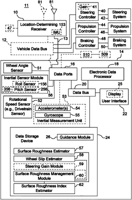
1. A method and system for estimating surface roughness of a ground for an off-road vehicle to control steering, the method comprising:
detecting motion data of an off-road vehicle traversing a field or work site during a sampling interval, the motion data comprising ground speed of the off-road vehicle;
detecting pitch acceleration data of the off-road vehicle for the sampling interval;
detecting roll acceleration data of the off-road vehicle for the sampling interval; and
determining a surface roughness index based on the detected motion data, pitch acceleration data and roll acceleration data for the sampling interval;
estimating zones with corresponding surface roughness index ranges within a field or work site based on the determined surface roughness index as a vehicle traverses or traversed the field or work site over multiple sampling intervals;
generating a graphical display that illustrates the estimated zones of corresponding surface roughness indexes or surface roughness index ranges within the field or work site; and
displaying the graphical display to a user or operator of the off-road vehicle.
|