| CPC G05D 1/106 (2019.05) [B64D 47/08 (2013.01); G01C 11/06 (2013.01); G01C 21/32 (2013.01); G06V 20/13 (2022.01); B64C 2201/028 (2013.01); B64C 2201/123 (2013.01); B64C 2201/127 (2013.01); B64C 2201/141 (2013.01); B64C 2201/146 (2013.01)] | 20 Claims |
|
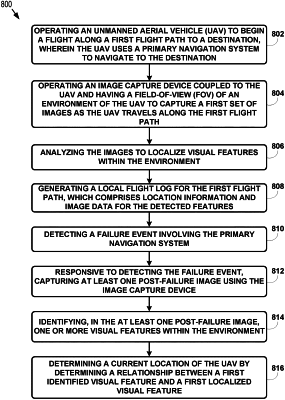
1. A computer-implemented method comprising:
during a flight along a first flight path to a destination by an unmanned aerial vehicle (UAV), operating an image capture device coupled to the UAV to capture a first set of one or more images of an environment of the UAV;
analyzing the first set of one or more images to identify a plurality of first structures within the environment;
generating a local flight log for the first flight path, wherein the local flight log associates one or more of the first structures with location information from a primary navigation system of the UAV;
determining a current location of the UAV by determining a relationship between at least one of the first structures and a first localized feature of a map;
comparing the current location of the UAV to the location information from the primary navigation system;
based on determining that a discrepancy between the current location and the location information from the primary navigation system is greater than a threshold, detecting a failure event involving the primary navigation system of the UAV; and
responsive to detecting the failure event:
capturing at least one post-failure image using the image capture device;
identifying, in the at least one post-failure image, one or more second structures within the environment; and
determining an updated current location of the UAV based on a relationship between (i) at least one of the second structures and (ii) at least one of: a second localized feature of the map or location information from the local flight log.
|