| CPC G06T 17/05 (2013.01) [G06T 7/20 (2013.01); G06T 7/80 (2017.01); G06T 19/20 (2013.01); G06T 2207/10016 (2013.01); G06T 2207/10028 (2013.01); G06T 2207/30241 (2013.01); G06T 2219/2012 (2013.01)] | 19 Claims |
|
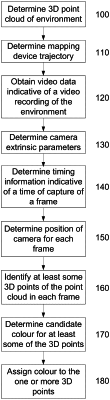
1. A method for use in colourising a three-dimensional (3D) point cloud of an environment, the method including in one or more electronic processing devices:
a) using geometric data captured by a mapping device to:
i) determine a 3D point cloud of the environment; and,
ii) determine a mapping device trajectory;
b) obtaining video data indicative of a video recording of the environment captured by a camera moving along a camera trajectory, the video data including a number of frames;
c) determining camera extrinsic parameters indicative of a transformation which transforms 3D points in a mapping device coordinate system to a camera coordinate system;
d) for each of a plurality of frames, the method includes:
i) determining timing information indicative of a time of capture of the frame;
ii) determining a position of the camera along the camera trajectory using the mapping device trajectory, the timing information and the camera extrinsic parameters;
iii) identifying at least some 3D points of the point cloud in the frame based at least in part on the position of the camera and determining a local point cloud that captures a scene in the immediate vicinity of the camera, wherein a visibility check is performed on the local point cloud to determine points in the local point cloud that are visible from the perspective of the camera for a given frame; and
iv) determining a candidate colour for the at least some of the 3D points using a colour of a corresponding pixel in the frame extracted from the video data; and,
e) assigning a colour to one or more points of the 3D point cloud using candidate colours obtained from multiple frames, wherein assigning the colour includes determining an angle between the viewpoint to a surface where each 3D point is located on, and assigning a colour using a colour corresponding to the 3D point where the angle is closest to 90 degrees.
|