| CPC G06Q 40/08 (2013.01) [B64C 39/024 (2013.01); G06V 10/44 (2022.01); G06V 10/7747 (2022.01); G06V 10/776 (2022.01); G06V 20/17 (2022.01); G06V 20/176 (2022.01)] | 16 Claims |
|
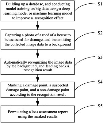
1. A method of assessing an insured loss, comprising:
S1: building up a database, and conducting model training on big data using a deep learning model or machine learning model to improve a recognition effect;
S2: capturing a photo of a roof of a house to be assessed for damage using an unmanned aerial vehicle, and transmitting, by the unmanned aerial vehicle, collected image data to a background;
S3: automatically recognizing the image data by the deep learning model or machine learning model running on the background, and feeding back, by the deep learning model or the machine learning model, a recognition result;
S4: automatically marking out, by the background, a damage point, a suspected damage point, and a non-damage point according to the recognition result; and
S5: formulating a loss assessment report using the marked results;
wherein the operation S2 comprises:
S21: determining whether a data collection target is global data collection or detailed data collection according to needs;
S22: in response to determining that the data collection target is the global data collection, controlling the unmanned aerial vehicle to fly at a relatively high altitude, collect global image data, and feed it back to the background; and
S23: in response to determining that the data collection target is the detailed data collection, controlling the unmanned aerial vehicle to fly at a relatively low altitude, collect detailed image data, and feed it back to the background.
|