| CPC G06F 30/20 (2020.01) [G06F 18/2113 (2023.01); G06F 18/214 (2023.01); G06F 18/2415 (2023.01); G06N 3/08 (2013.01); G06V 10/25 (2022.01); G06V 10/764 (2022.01); G06V 10/774 (2022.01); G06V 10/82 (2022.01); G06V 20/13 (2022.01)] | 18 Claims |
|
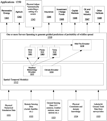
1. A method for generating gridded predictions of a probability of wildfire spread for geographies, comprising:
a) sensing, by one or more sensors, observational climate and earth surface data;
b) obtaining historical data on wildfire spread events, including data on a temporal evolution of perimeters of wildfire spread, and rates of wildfire spread, acquired from processing data from the one or more sensors or other sensors;
c) obtaining gridded climate data, wherein the gridded climate data comprises data of spatial grids changing over time, which include historical reanalysis data on variables including temperature, humidity, and wind speed;
d) creating a set of input features comprising geographically stacking and aligning the observational climate and earth data and the gridded climate data over a geographical region and at a specified period time;
e) creating a gridded wildfire data set comprising the historical data on wildfire spread events in which individual grid cells of a grid are identified with a ground truth mask, wherein the ground truth mask has a value representing whether or not fire is present within each grid cell of the grid within the geographical region and at the specified period of time;
f) training a model that learns one or more probabilistic mapping function emulators between the set of input features and the gridded wildfire data set within the geographical region and at the specified period of time, which predicts a first probability of wildfire occurrence and a rate and extent of wildfire spread within the geographical region and at the specified period of time; and
g) generating gridded wildfire prediction data including a second probability of wildfire occurrence and spread within the geographical region, using the model and a new set of input features over the geographical region but for a different time period;
wherein one or more wildfire spread event is modified or augmented by prior physical damage data that includes information of prior physical damage to human structures sustained in previous wildfires, wherein the human structures include buildings and property, and the prior physical damage data includes dollar losses sustained; and
further comprising determining whether to insure and/or a price of insurance of an individual property based on a probability of the individual property being damaged by wildfire based on a predicted probability of damage of the individual property.
|