| CPC G01N 33/1826 (2013.01) [G01N 30/8637 (2013.01); G01N 30/8693 (2013.01)] | 12 Claims |

|
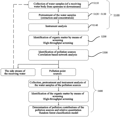
1. A method for intelligent source tracing of organic pollution of a water body, comprising:
acquiring organic matter analysis and detection data from a plurality of water samples of a polluted water body from upstream to downstream through high performance liquid chromatography-tandem mass spectrometry;
performing high-throughput screening on the organic matter in the water samples according to the analysis and detection data to determine pollutants in the water body;
identifying pollution sources by means of network analysis according to the determined pollutants; and
according to the identified pollution sources and the organic pollutants in the receiving water body at the pollution sources, determining key pollutants in the pollution sources and quantifying the pollution contributions of the key pollutants by using a machine learning classification model;
wherein identifying pollution sources by means of network analysis according to the determined pollutants comprises:
calculating the correlation of the peak areas of the organic pollutants, constructing a correlation-based pollutant network according to the correlation, and performing group classification on the pollutant network;
according to the pollutant groups, drawing change curves of the peak areas of the pollutants in the groups and change curves of mean peak areas of the pollutants in the groups; and
according to the sites where the change curves of the mean peak areas of the pollutants in the large groups sharply increase from upstream to downstream, determining location intervals of potential pollution sources, and meanwhile, considering the consistency of the peak areas of the pollutants in the groups at the sites, determining the pollution sources according to actual geographic information;
wherein calculating the correlation of the peak areas of the organic pollutants, constructing a correlation-based pollutant network according to the correlation, and performing group classification on the pollutant network, comprises:
calculating the correlation of the peak areas of the organic pollutants in the water samples of the receiving water body from upstream to downstream, taking the correlation relationship as an edge and the pollutants as nodes, inputting them into the network analysis software, such as Gephi or Cytoscape to construct the correlation-based pollutant network, and performing modular analysis to obtain a group classification result of the pollutant network;
wherein according to the categories of the pollutant groups, drawing change curves of the peak areas of the pollutants in the groups and change curves of mean peak areas of the pollutants in the groups comprises:
standardizing the peak areas of the pollutants in the water samples from upstream to downstream, and drawing change curve graphs of the peak areas of the pollutants in the groups according to the categories of the pollutant groups;
according to the categories of the pollutant groups, calculating mean values of the peak areas of the pollutants at each site to obtain the change curves of the mean peak areas of the pollutants in the groups.
|