| CPC G01C 15/00 (2013.01) | 1 Claim |
|
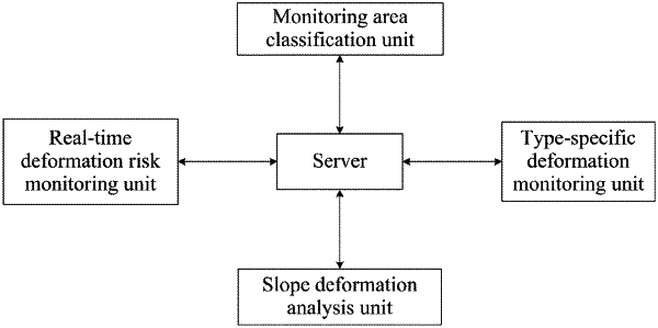
1. A data analysis-based intelligent deformation monitoring system for mountain landslides, comprising a server, which is communicatively connected to the following components:
a monitoring area classification unit configured to perform classification on a mountainous area to divide the mountainous area into i sub-areas, wherein i is a natural number greater than 1; obtain respective classification coefficients of the sub-areas within the mountainous area; and classify each of the sub-areas as a low-hardness area or a high-hardness area based on the classification coefficients, and send results to the server;
a type-specific deformation monitoring unit configured to perform deformation monitoring on the sub-areas of different types, generate a high-hardness area deformation warning signal, a signal indicating that the high-hardness area is stable, a low-hardness area deformation warning signal, and a signal indicating that the low-hardness area is stable through analysis, and send the signals to the server;
a slope deformation analysis unit configured to perform a slope deformation analysis within a landslide area, mark a sub-area where a landslide occurs as a landslide area, mark a real-time sliding direction within the landslide area as a landslide flow direction, set areas at both sides of the landslide flow direction as landslide slopes, generate a control adjustment signal or a risk monitoring signal through landslide slope analysis, and send the signal to the server; and
a real-time deformation risk monitoring unit configured to monitor risks in a real-time landslide process within the landslide area, analyze the landslide process in the landslide area, divide the landslide area into a front landslide area and a rear landslide area based on the landslide flow direction, perform analysis to generate a signal for control enhancement or a signal indicating no instantaneous risk, and send the signal to the server;
wherein an operating process of the monitoring area classification unit is as follows:
collecting a ratio of soft body volume to hard body volume in each sub-area within the mountainous area, as well as a soil moisture content in each sub-area; collecting a daily average soil erosion in each sub-area within the mountainous area; and obtaining the classification coefficient of each sub-area within the mountainous area through analysis; and
comparing the classification coefficient of each sub-area within the mountainous area with a classification coefficient threshold:
if the classification coefficient of a sub-area within the mountainous area exceeds the classification coefficient threshold, marking the corresponding sub-area as a low-hardness area; if the classification coefficient of a sub-area within the mountainous area does not exceed the classification coefficient threshold, marking the corresponding sub-area as a high-hardness area; and sending corresponding numbers of the low-hardness areas and high-hardness areas to the server;
an operating process of the type-specific deformation monitoring unit is as follows:
when a sub-area is a high-hardness area, collecting lateral and vertical extension span values of cracks in the high-hardness area, as well as a frequency of lateral and vertical crack extensions; and comparing the span values with an extension span threshold and comparing the frequency with a lateral and vertical extension threshold:
if the lateral and vertical extension span values of the cracks in the high-hardness area exceed the extension span threshold, or if the frequency of lateral and vertical crack extensions exceeds the lateral and vertical extension threshold, generating a high-hardness area deformation warning signal and sending the high-hardness area deformation warning signal to the server; or if the lateral and vertical extension span values of the cracks in the high-hardness area do not exceed the extension span threshold and the frequency of lateral and vertical crack extensions does not exceed the lateral and vertical extension threshold, generating a signal indicating that the high-hardness area is stable and sending the signal to the server;
when a sub-area is a low-hardness area, a soil height deviation between symmetrical regions at both sides within the low-hardness area and a soil erosion difference between symmetrical regions at both sides within the low-hardness area are collected, and the soil height deviation is compared with a height difference threshold, and the soil erosion difference is compared with an erosion difference threshold:
if the soil height deviation between the symmetrical regions at both sides within the low-hardness area exceeds the height difference threshold, or if the soil erosion difference between the symmetrical regions at both sides within the low-hardness area exceeds the erosion difference threshold, a low-hardness area deformation warning signal is generated and the low-hardness area deformation warning signal is sent to the server; and
if the soil height deviation between the symmetrical regions at both sides within the low-hardness area does not exceed the height difference threshold, and the soil erosion difference between the symmetrical regions at both sides within the low-hardness area does not exceed the erosion difference threshold, a signal indicating that the low-hardness area is stable is generated, and the signal is sent to the server; wherein after receiving the low-hardness area deformation warning signal or high-hardness area deformation warning signal, the server performs landslide control on the corresponding sub-area, and selects a suitable landslide control method according to a type of the sub-area, wherein for the high-hardness area, control points are set up and supported, and for the low-hardness area, a control network is set up to provide overall coverage for the corresponding area, thereby reducing a landslide risk;
an operating process of the slope deformation analysis unit is as follows:
collecting an excess lateral movement velocity and an excess landslide flow direction velocity, as well as an excess amount of lateral movement and an excess amount of landslide flow direction movement of the landslide slope in the landslide area during the landslide process, comparing the excess lateral movement velocity and the excess landslide flow direction velocity with an excess velocity threshold, and comparing the excess amount of lateral movement and the excess amount of landslide flow direction movement with an excess movement amount threshold:
if the excess lateral movement velocity and the excess landslide flow direction velocity of the landslide slope in the landslide area during the landslide process exceed the excess velocity threshold, or if the excess amount of lateral movement and the excess amount of landslide flow direction movement exceed the excess movement amount threshold, generating a control adjustment signal and sending the control adjustment signal to the server, wherein after receiving the control adjustment signal, the server adjusts control regions of the landslide area based on a real-time slope deformation amount of the landslide area, and rationally allocates control resources of the real-time landslide area, so as to minimize landslide impacts; or if the excess lateral movement velocity and the excess landslide flow direction velocity of the landslide slope in the landslide area during the landslide process do not exceed the excess velocity threshold, and the excess amount of lateral movement and the excess amount of landslide flow direction movement do not exceed the excess movement amount threshold, generating a risk monitoring signal and sending the risk monitoring signal to the server; and
an operating process of the real-time deformation risk monitoring unit is as follows:
collecting excess movement velocities corresponding to the front landslide area and rear landslide area within the landslide area, as well as an increase rate of a soil accumulation difference between the rear landslide area and the front landslide area, comparing the excess movement velocities with an excess movement velocity threshold, and comparing the increase rate of the soil accumulation difference with an accumulation difference increase rate threshold:
if the excess movement velocities corresponding to the front landslide area and rear landslide area within the landslide area exceed the excess movement velocity threshold, or if the increase rate of the soil accumulation difference between the rear landslide area and the front landslide area exceeds the accumulation difference increase rate threshold, generating a control reinforcement signal and sending the control reinforcement signal to the server, wherein after receiving the control reinforcement signal, the server reinforces control over the corresponding landslide area, that is, increases the number of support points or the number of control regions; or if the excess movement velocities corresponding to the front landslide area and rear landslide area within the landslide area do not exceed the excess movement velocity threshold, and the increase rate of the soil accumulation difference between the rear landslide area and the front landslide area does not exceed the accumulation difference increase rate threshold, generating a signal indicating no instantaneous risk and sending the signal to the server.
|