| CPC G08B 25/006 (2013.01) [G06F 16/29 (2019.01); G06Q 50/26 (2013.01); H04N 7/181 (2013.01)] | 20 Claims |
|
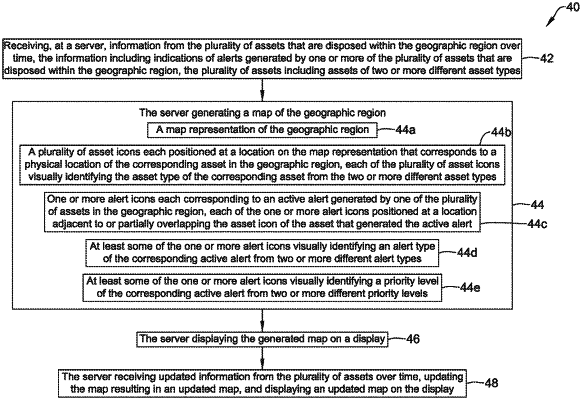
1. A method of monitoring a geographic region for alerts generated by a plurality of assets disposed within the geographic region, the method comprising:
receiving, at a server, information from the plurality of assets that are disposed within the geographic region over time, the information including indications of alerts generated by one or more of the plurality of assets that are disposed within the geographic region;
the server generating a map of the geographic region that includes:
a map representation of the geographic region;
a plurality of asset icons each positioned at a location on the map representation that corresponds to a physical location of the corresponding asset in the geographic region;
one or more alert icons each corresponding to an active alert generated by one of the plurality of assets in the geographic region, each of the one or more alert icons positioned on the map representation to visually associate the corresponding alert icon with the corresponding asset that generated the active alert, wherein at least one of the one or more alert icons visually identifying one or more of:
an alert type of the corresponding active alert from two or more different alert types;
a priority level of the corresponding active alert from two or more different priority levels;
the server displaying the generated map on a display; and
the server receiving updated information from the plurality of assets over time, updating the map resulting in an updated map, and displaying an updated map on the display.
|