| CPC G01V 20/00 (2024.01) [E21B 7/046 (2013.01); E21B 47/12 (2013.01); E21B 49/02 (2013.01); G06T 17/05 (2013.01); E21B 2200/20 (2020.05)] | 17 Claims |
|
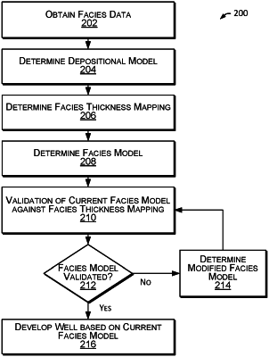
1. A method of developing a hydrocarbon well, the method comprising:
obtaining facies data for a subsurface formation, the facies data comprising:
vertical wellbore core data obtained by way of core samples extracted from vertical portions of wellbores of wells that extend into the subsurface formation, the vertical wellbore core data comprising characteristics of the core samples measured in a core laboratory after extraction of the core; and
wireline log data obtained by way of downhole logging of wellbores of wells that extend into the subsurface formation, the wireline log data comprising characteristics of rock of the subsurface formation measured in-situ by way of a downhole logging tool, the wireline log data comprising:
vertical wireline log data that corresponds to downhole logging of vertical portions of the wellbores of the wells that extend into the subsurface formation; and
horizontal wireline log data that corresponds to downhole logging of horizontal portions of the wellbores of the wells that extend into a target interval of the subsurface formation;
determining, based on the vertical wellbore core data and the vertical wireline log data, a depositional model of the subsurface formation, wherein the depositional model comprises a 3D grid of the types and locations of rock of the subsurface formation based on the characteristics of the core samples and the characteristics of rock of the subsurface formation;
determining, based on the facies data, a facies model of a horizontal portion of a wellbore of a hydrocarbon well that extends into the target interval of the subsurface formation, the facies model of the horizontal portion of the wellbore comprising a predicted facies log that identifies predicted facies of formation rock along a length of the horizontal portion of the wellbore of the hydrocarbon well, wherein determining the facies model comprises determining the facies model based artificial neural network (ANN) processing of the facies data;
determining, based on the depositional model, a facies thickness mapping of the subsurface formation, the facies thickness mapping identifying locations of facies of formation rock in the subsurface formation, the facies thickness mapping comprising a 3D grid of mapping the upper and lower bounding surfaces of the facies based on the types and locations of rock of the subsurface formation from the depositional model, wherein the facies thickness mapping further comprises first, second, and third boundaries that define bounding surfaces of first, second, third, and fourth rock layers of the subsurface formation, wherein the first boundary includes the earth's surface and the second and third boundaries define a reservoir that defines a target interval of the subsurface formation;
determining, based on a comparison of the predicted facies log and the facies thickness mapping, for each of one or more locations within the subsurface formation, a discrepancy between the predicted facies of formation rock indicated for the location by the predicted facies log and the facies of formation rock indicated for the location by the facies thickness mapping;
for one or more of the locations of a discrepancy identified, modifying the predicted facies for the location based on the facies of formation rock indicated for location by the facies thickness mapping, to generate a modified predicted facies log;
determining, based on the modified predicted facies log, a parameter of the horizontal wellbore of the hydrocarbon well; and
developing the hydrocarbon well in accordance with the parameter.
|