| CPC G06T 3/4038 (2013.01) [G06T 1/0007 (2013.01)] | 19 Claims |
|
18. A computer system, comprising:
one or more processors; and
one or more non-transitory memory storing processor executable code and interior geometry calibration data for one or more cameras, the one or more non-transitory memory communicating with the one or more processor;
wherein the processor executable code, when executed by the one or more processors, causes the one or more processors to:
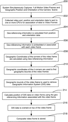
analyze pixels of video frames, captured by one or more camera, to generate geo-referencing data for one or more of the video frames by utilizing data related to the camera, including geographic position data, orientation data, and interior geometry calibration data, wherein the geo-referencing data comprises geographic locations of the pixels of the video frames;
determine geographical boundaries of the video frames from the geo-referencing data, based at least in part on geographic coordinates of corners of the video frames, which are based on the geo-referencing data for pixels of the video frames;
access geographic information system (GIS) data using one or more of the determined geographical boundaries of the video frames;
determine an overlay position of the GIS data relative to the video frames for which geo-referencing data is generated in real-time based at least in part on the generated geo-referencing data, wherein real-time is within a frame rate used for full motion video;
associate the GIS data with the video frames utilizing the overlay position of the GIS data;
assemble the video frames into a full motion video series; and
enable display of the full motion video series in real-time with the overlaid GIS data.
|