| CPC G06T 17/05 (2013.01) [G06T 7/70 (2017.01); G06T 2200/04 (2013.01); G06T 2200/08 (2013.01)] | 15 Claims |
|
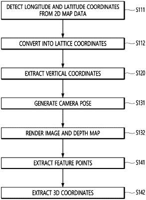
1. A method of generating a map for visual localization, comprising:
acquiring 3-dimensional (3D) model data which is based on an image of an outdoor space captured from air, the image of the outdoor space including a plurality of images captured by a camera while the camera is moving;
generating lattice coordinates along a sidewalk positioned near a road by using two-dimensional (2D) map data of the outdoor space;
extracting vertical coordinates corresponding to the lattice coordinates, from the 3D model data which is based on the image of the outdoor space captured from the air;
generating 3D coordinates along the sidewalk based on the lattice coordinates and the vertical coordinates;
specifying a virtual camera pose by using the 3D coordinates, the virtual camera pose including a position and a posture to capture a point inside the outdoor space from a viewpoint of the sidewalk;
rendering the image of the outdoor space from a perspective of the virtual camera, by using the virtual camera pose and the 3D model data, the image of the outdoor space being rendered from a viewpoint of the virtual camera using the 3D model data; and
generating a feature point map by using the rendered image and the virtual camera pose,
wherein the generating of the feature point map includes extracting a plurality of feature points from the rendered image, the plurality of feature points including, for at least one structure included in the rendered image, at least two feature points of the at least one structure.
|