| CPC G05D 1/0221 (2013.01) [B60W 60/001 (2020.02); G05D 1/0246 (2013.01); G06N 5/04 (2013.01); G06N 20/00 (2019.01); B60W 2420/42 (2013.01); B60W 2554/20 (2020.02); B60W 2554/402 (2020.02); B60W 2554/4029 (2020.02); B60W 2555/60 (2020.02)] | 18 Claims |
|
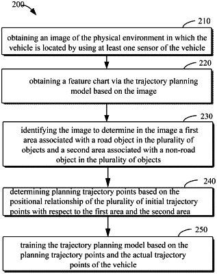
1. A method for training a trajectory planning model, comprising:
obtaining an image of a physical environment in which a vehicle is located via at least one sensor of the vehicle, wherein the obtained image comprises a plurality of objects surrounding the vehicle;
obtaining a feature chart from the trajectory planning model based on the image, the feature chart indicating a plurality of initial trajectory points of the vehicle in the image;
identifying the image to determine in the image a first area associated with a road object in the plurality of objects and a second area associated with a non-road object in the plurality of objects, wherein identifying the image comprises: obtaining a depth image via a trained depth estimation network, wherein each pixel value of the depth image is a distance between a point in the image of the physical environment and the vehicle, and obtaining the first area associated with the road object by multiplying the depth image with a matrix array having a first value corresponding to the first area and a second value corresponding to the second area;
determining planning trajectory points based on a positional relationship of the plurality of initial trajectory points with respect to the first area and the second area; and
training the trajectory planning model based on the planning trajectory points and actual trajectory points of the vehicle.
|