| CPC G01V 1/50 (2013.01) [G01V 1/282 (2013.01); G01V 1/306 (2013.01); G01V 2210/6222 (2013.01); G01V 2210/6224 (2013.01); G01V 2210/67 (2013.01)] | 12 Claims |
|
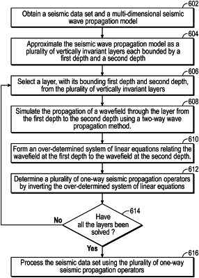
1. A method, comprising:
obtaining, from a seismic survey, a seismic data set and a multi-dimensional seismic wave propagation velocity model;
using a seismic processing system:
approximating the seismic wave propagation velocity model as a plurality of layers each bounded by a first bounding depth and a second bounding depth,
for each of the plurality of layers:
simulating propagation of a seismic wave from the first bounding depth to the second bounding depth using a two-way seismic wave propagation simulator;
forming an over-determined system of linear equations relating at least one mono-frequency component of the seismic wave at the first bounding depth to at least one mono-frequency component of the seismic wave at the second bounding depth;
determining a plurality of one-way seismic wave propagation operators by inverting the over-determined system of linear equations; and
verifying that the plurality of one-way seismic wave propagation operators has been determined for each layer of the plurality of layers,
processing the seismic data set using at least one of the one-way seismic wave propagation operators for at least one of layer;
using a computer processor:
determining a presence and a location of a hydrocarbon reservoir based, at least in part, on the processed seismic data set, and
determining a borehole trajectory through a subterranean region of interest based, at least in part, on the presence of the hydrocarbon reservoir; and
drilling, using a drilling system, a borehole guided by the borehole trajectory.
|