| CPC B60W 60/001 (2020.02) [B60W 40/10 (2013.01); G01C 21/3841 (2020.08); G01C 21/3896 (2020.08); G08G 1/096708 (2013.01); B60W 2420/00 (2013.01); B60W 2552/50 (2020.02); B60W 2554/20 (2020.02); B60W 2556/40 (2020.02); B60W 2756/10 (2020.02)] | 23 Claims |
|
1. An autonomous vehicle control system resident in an autonomous vehicle, comprising:
one or more processors; and
memory storing instructions that, when executed by the one or more processors, cause the autonomous vehicle control system to:
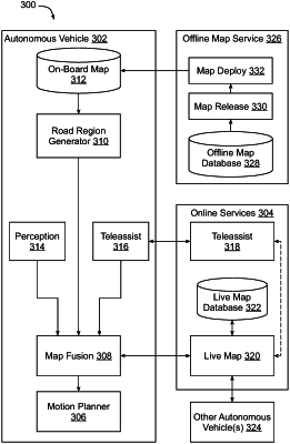
store offline map data of a portion of an environment, the offline map data defining a plurality of static elements within the portion of the environment, and the offline map data generated from aggregated observations collected by and/or verified by multiple autonomous vehicles in a fleet of autonomous vehicles, validated by an offline process, and deployed to the fleet of autonomous vehicles as a versioned update;
store observation data received from a remote live map system and associated with one or more observations collected from the environment by one or more other autonomous vehicles in the fleet and not represented in the offline map data for the portion of the environment, wherein the one or more observations includes at least one perception observation of a stationary sign, construction element, boundary, or blockage region;
receive a digital map of the portion of the environment and generated from the offline map data stored in the autonomous vehicle;
augment the digital map with the stored observation data while maintaining the offline map data stored in the autonomous vehicle to generate an augmented digital map that represents one or more of the plurality of static elements in addition to the one or more observations, wherein generation of the augmented digital map overrides at least a portion of the offline map data based upon the at least one perception observation of the stationary sign, construction element, boundary, or blockage region; and
control the autonomous vehicle using the augmented digital map.
|