| CPC G06T 7/75 (2017.01) [G06T 7/194 (2017.01); G06T 2207/10028 (2013.01); G06T 2207/30196 (2013.01)] | 20 Claims |
|
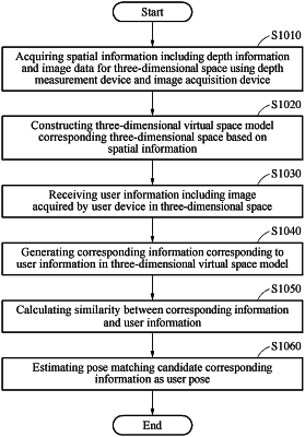
1. A method of estimating a user pose for a three-dimensional space, comprising:
a step of acquiring spatial information comprising depth information and image information for a three-dimensional space representing a real space using a depth measurement device and an image acquisition device;
a step of configuring depth-image associated information based on the spatial information and constructing a three-dimensional virtual space model corresponding to the real space and the three-dimensional space based on the depth-image associated information;
a step of receiving user information, comprising an image acquired by a user device, in the three-dimensional space;
a step of generating corresponding information corresponding to the user information in the three-dimensional virtual space model;
a step of calculating a similarity between the corresponding information and the user information; and
a step of estimating the user pose based on the similarity,
wherein the real space is a space, in which a discontinuous spatial map is generated when a spatial map is constructed using point cloud information,
wherein the real space comprises at least one of an indoor space, an outdoor space, and a space, in which the indoor space and outdoor space are linked, and
wherein the step of estimating the user pose comprises,
identifying a plurality of candidate poses and corresponding information for an entire area;
recalculating the similarity around a candidate pose of the plurality of candidate poses using the corresponding information;
repeating the recalculation for all of the plurality of candidate poses; and
estimating the user pose as one pose around the candidate pose with the highest similarity during the recalculation.
|