| CPC G05D 1/0212 (2013.01) [G01C 21/3815 (2020.08); G01C 21/3841 (2020.08); G05D 1/027 (2013.01); G05D 1/0231 (2013.01); G05D 1/0276 (2013.01); G05D 1/0278 (2013.01)] | 17 Claims |
|
1. A method for controlling an Autonomous Vehicle (AV), comprising:
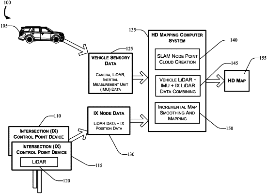
generating, by a first intersection (IX) control device comprising a first Light Detection and Ranging (LiDAR) system and a second IX control device comprising a second LiDAR system, first sensory data comprising first dimensional information and first position information of a stationary environmental feature in a mapped region;
receiving, via a processor, from the first IX control device and the second IX control device, the first sensory data;
collecting, by one or more sensors disposed in the AV, a LiDAR point cloud and Simultaneous Localization and Mapping (SLAM) data associated with the stationary environmental feature in the mapped region while the AV is driving along one or more roadways in the mapped region;
receiving, via the processor, from the AV, the LiDAR point cloud and the SLAM data;
generating, via the processor, based on a combination of the LiDAR point cloud and the SLAM data, second sensory data comprising second dimensional information and second position information of the stationary environmental feature in the mapped region;
generating, via the processor, a plurality of IX node data points based on a combination of the first sensory data and the second sensory data, wherein the plurality of IX node data points comprises a first IX node data point associated with the first IX control device and a second IX node data point associated with the second IX control device;
generating an optimized High-Definition (HD) map comprising the stationary environmental feature in the mapped region by smoothing the plurality of IX node data points using a batch optimization algorithm, wherein the batch optimization algorithm uses the first IX node data point as a first static IX control point and the second IX node data point as a second static IX control point; and
navigating the AV along the one or more roadways in the mapped region using the optimized HD map.
|