| CPC G01C 21/38 (2020.08) [B60W 50/00 (2013.01); B60W 60/001 (2020.02); G01S 13/867 (2013.01); G01S 13/931 (2013.01); B60W 2050/0057 (2013.01); B60W 2420/42 (2013.01); B60W 2552/53 (2020.02); B60W 2556/50 (2020.02)] | 18 Claims |
|
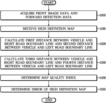
1. An autonomous driving system, comprising:
a first sensor installed in a vehicle, having a field of view facing in front of the vehicle, and configured to acquire front image data;
a second sensor selected from the group consisting of a radar and a light detection and ranging (lidar), installed in the vehicle, having a detection field of view facing in front of the vehicle, and configured to acquire forward detection data;
a communicator configured to receive a high definition map at a current location of the vehicle from an external server; and
a controller including a processor configured to process the high definition map, the front image data, and the forward detection data; wherein
the controller is configured to:
calculate a first distance between the vehicle and a right road boundary line and a second distance between the vehicle and a left road boundary line in response to processing the front image data and the forward detection data,
calculate a third distance between the vehicle and the right road boundary line and a fourth distance between the vehicle and the left road boundary line in response to processing the high definition map,
determine a map quality index of the high definition map based on at least one of a difference between the first distance and the third distance or a difference between the second distance and the fourth distance,
correct coordinates of the vehicle on the high definition map based on the at least one of a difference between the first distance and the third distance or a difference between the second distance and the fourth distance to correct the determined map quality index,
determine whether an error of the high definition map is present based on the corrected map quality index, and
transfer a control right of the vehicle to a driver in response to a determination that the error of the high definition map is present.
|