| CPC G01V 3/083 (2013.01) [E21B 47/13 (2020.05); E21B 49/001 (2013.01); G01V 3/12 (2013.01)] | 22 Claims |
|
1. A method, comprising:
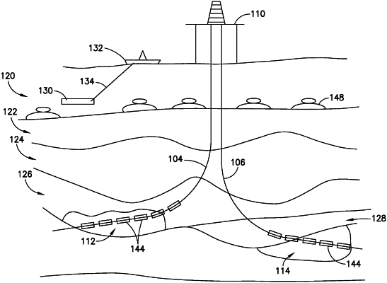
dispersing one or more borehole receivers in one or more boreholes;
distributing one or more marine receivers in marine water at a seabed;
immersing an electromagnetic source in the marine water above the seabed;
energizing the electromagnetic source to generate electromagnetic waves;
measuring one or more borehole signal measurements using the one or more borehole receivers, wherein the one or more borehole signal measurements comprise propagations of the electromagnetic waves received at respective borehole receivers;
measuring one or more seabed signal measurements using the one or more marine receivers, wherein the one or more seabed signal measurements comprise reflections of the electromagnetic waves from earth subsurface strata of the seabed received at respective marine receivers; and
determining, via a processor, a three-dimensional property distribution of a reservoir of interest by:
using the one or more seabed signal measurements to determine electromagnetic parameters of the earth subsurface strata intervening between the seabed and the reservoir of interest via a first inversion operation;
using the one or more borehole signal measurements and the electromagnetic parameters of the earth subsurface strata to generate inverted one or more borehole signal measurements via a second inversion operation; and
determining the three-dimensional property distribution of the reservoir of interest based on the inverted one or more borehole signal measurements.
|